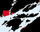
Wolfe Island
North to CEDAR & MILTON ISL. |
Wolfe Island
North to CEDAR & MILTON ISL. |
| Wolfe Island |
| 44 degrees 10 minutes North 76 degrees 25 minutes West |
|
Wolfe Island is a large Island separated from the United States mainland by the south St Lawrence Seaway Channel at the beginning of the St Lawrence River. Wolfe Island has a conspicuous RADIO TOWER near the centre of the SW part of the Island, with air obstruction lights with an elevation of 271 M or (889 feet). 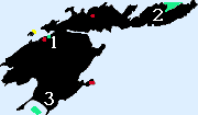
Wolfe Island is named for General Wolfe, who died in the Plains of Abraham where he defeated General Montcalm,setting the stage for our present day Canada. The capital of Upper Canada is Queen's Park, Toronto, The civil law of Upper Canada is based on the English common law, much like eight other provinces outside Lower Canada. While French-language services were introduced "where numbers justify" in former premier David Peterson's Bill 8, there is no formal constitutional requirement for French in Upper Canada. Upper Canada (now Ontario) was split from French-speaking Lower Canada (now Qu�bec) in 1784 to accommodate an influx of English-speaking United Empire Loyalists and still has an English-speaking majority despite attracting the lion's share of recent immigrants. Wolfe Island, the largest of the Thousand Islands is two and one half miles south east of Kingston, connected by a year round ferry service. Wolfe Island has a full time community living in the four towns on the island. Marysville on the north shore of Bartlett Bay, Port Alexandria on the southernmost tip with a ferry to Cape Vincent, Scotch Settlement approximately on third of the way east on the north section close to Holiday Bay and Port Metcalfe at the extreme eastern most tip. 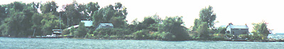
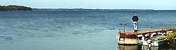
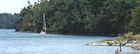
As most visitors approach from Kingston we shall begin with Marysville where the Kingston ferry lands approximately every 20 minutes, year round. On your approach from the north you will pass Garden Island to your west, the island was once home to a active shipbuilding community. As you pass the north east tip of Garden Island the deserted house on the point exemplifies what has become of the shipbuilding industry. On the south face of the point overlooking the shallow and wreck strewn bay you can still see the slipway and remainder settlement on the end of the island. 
As you approach Wolfe Island from the north west you must be aware of the shallow obstruction strewn shoals to the east of Garden Island when entering Barrett Bay. There is a lit green channel marker in the middle of the passage between Garden Island and Marysville as you approach two small islets known as Goose Island. the water surrounding the islets is extremely shallow and requires a wide berth. 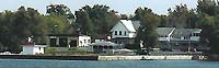
Marysville itself has a grocery store and is home to the General Wolfe Hotel and Marina (1), located to the east of the ferry dock, where there is transient docking for approximately 20 visiting boats with normal facilities, enhanced by the hotels facilities, offering free docking for those dining at the hotel. In peak season this is a popular stop and reserving ahead is a must. 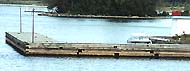
After visiting the marina I would question if there is 5 feet of water and suggest that any cruising boats approach with caution and only attempt to use the outside of the L shaped dock where we found 4 feet of water in September 2000. The hotel itself provided more of a watering hole than exotic dining frequented by friendly locals. The gas station is directly across the road from the marina if you should require gas and have your own container. Most maps and charts of the area are large scale leading to the impression that the island is more populated and built up than it is. On the south most tip of the western most half 11 K from Marysville is Port Alexandria where a ferry operates to St Vincent. There are no marina facilities here and no shelter with the rocky beach only supporting a few houses and customs station.
Grenadier Eastward . Gananoqe . Ivy Lee . Brockville |