
Brockville |
Brockville |
Brockville is the end of the Thousand Islands and reportedly the fastest growing area in Ontario. It is another of the lovingly restored towns that dot the north shore of this area, along with a major redevelopment project. Located 32 miles from Gananoque. 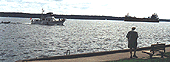
When approaching Brockville from the river the first difference one notices is that there is a current of 1 to 2 knots and we recommend that before you rush in you power down with some distance to shore so that you will encounter no surprises. If you are sailing leave yourself time and you have prevailing wind and the current with you. 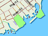
Click image for large map. 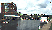
From down river and Prescott your only obstacle is the Seven Sisters Islands . You can choose to either follow the illuminated and flashing red and green markers north of the islands or continue south and pass between the USA shore and the island which is not a good idea with the current and when your wind will usually desert you once between the islands, leaving a pure sail powered boat in an awkward situation. From the Thousand Islands and Brock Islands you have the current under your stern. The channel between the end of the Brock Group is well marked and straight forward, but ... BUSY. Provisioning is easy as King Street is a block away with groceries liquor store, dozens of shops and all services close by. The Municipal Marina is easily identified by the tall apartment building looming over this modern facility. You enter from the west end, between the extensive landfill called the Blockhouse Island Break wall Park and the shore. The end of the breakwater is marked by a FI Red and the path is absolutely obstruction free. 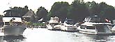
As you enter the protected bay within this break wall the (4) City Marina and (4) Tunnel Bay are immediate ahead while (3) Excell Marine in north with a substancial dock extending outwards. The City Marina can accommodate 75 transient boats within the break wall in 8 to 15 feet of water. When you arrive check in at the Harbour Services Building for a allocation. Services are in the same building. It is probably a good idea to call ahead as the marina is well staffed in summer and you can use you cell or CH 68 to make a reservation. |
|
MARINE
|