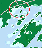
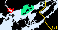
Not for navigation, always Hydrographic Charts


Close E. Kingston  .  Lake Fleet  .  Navy  .  Bridge  .  Grenadier
Eastward  .  Gananoqe  .  Ivy Lee  .  Brockville


Lake Fleet Islands

The Lake Fleet Islands

Are found south east of the Admiralty Group off the north shore of Grindstone Island, many are within a stones throw of the International boundry.


The Fleet Islands

Canadian Hydrographic Charts: 2017, 1439, 1436, 1437, 1438 USA 1439
 
Lake Fleet

[ For large Lake Fleet map go here ]
 
Canadian Hydrographic Charts: - charts 1437, 1438
# 3  on map as
Mead , Jolly &
Fat Huckelberry Islands
Mead , Jolly & Fat Huckelberry Islands offer a couple of anchorages.
# 1  on map as
Camelot Isl
Camelot Isl has both mooring buoys and docks with island access.
# 3  on map as
Endymion Isl
Endymion Isl has both mooring buoys, dinghy ramp, 3 sets of docks with island access remaining my favorite.
# 2  on map as
Niagara Isl
Niagara Isl
# 6  on map as
Sugar Isl
Sugar Isl offers an anchorage to the north.
# 6  on map as
Prince Regent Gananoque Narrows
Prince Regent Gananoque Narrows has a sheltered spot from prevailing winds but is open to the tour boat wake.


Navy Islands

The Navy Islands

Lie close to the Canadian shore north of the Gananoque Narrows and Canadian Ciddle Channel upstream of the Bridge.

Canadian Hydrographic Charts: charts 1437, 1438
 
Navy Islands small map

[ For large Navy Islands
map go here ]
 
not on map
Gordon Isl
Gordon IslLocated to the west of this N of the main channel to Gananoque, west of the Narrows.
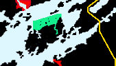
# 1  on map as
Stave
Stave has docks and an anchorage with good shelter.
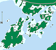
# 2  on map as
Hickey
Hickey anchorage offers shelter with depth for larger boats, perfect for exploring with your dinghy.
# 3  on map as
Downie Isl
Downie Isl anchorage is a little weedy but tucked away.
# 4  on map as
Mulcaster Isl
Mulcaster Isl is tucked between Downie, Ninette, and Potato Islqnd with docks and anchorages.
# 5  on map as
Ninette
Ninette is tucked away to the west of Mulcaster.
# 6  on map as
Lancaster Isl
Lancaster Islis close off the north shore.

Ivy Lea - charts 1437

Ivy Lea Ivy Lea Resort is between the Navy Islands and the Bridge on the north shore.


Close E. Kingston  .  Lake Fleet  .  Navy  .  Bridge  .  Grenadier
Eastward  .  Gananoqe  .  Ivy Lee  .  Brockville


Please, E Mail us any corrections or your input

Copyright 1998, Revised 1999, 2000, 2001, 2002 All rights reserved