|
Kingston I Amherst Isl I Adolophs Reach I Bath I Pryners Cove I Glenora I Picton I
Hay Bay I Long Reach I Deseronto I Belleville I Trenton I Murray Canal I Presqu'ile Bay |
 Trenton and Approaches |
| Trenton | Buoy QTA | 44°05.93' :N | 77°30.87' :W |
Trenton to The NarrowsTrenton is at the south end of the Trent-Severn Waterway, a series of Lakes, rivers and canals. It is approximately 390 Kms.long and joins Lake Ontario to Georgian Bay to the NE. Approaching Trenton from the Murray Canal one must stay close to the south shore keeping the red buoys off Indian Island Bank on the port side. 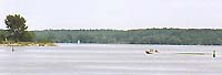
Chart 2021 shows a passage from QT16 to the flashing red Q72. This passage has shown to have a minimum depth of 7 ft. The City of Trenton maintains two Marinas, both with launching ramps, one on each side of the mouth of the Trent. 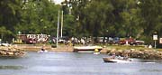
As one approaches Trenton, at the mouth of the river Trent, On the east shore one sees on their right Centennial Park with the Robert Patrick Marina at the end of the park. The entrance is sheltered and gives way to a comfortable marina on the inner basin. The Robert Patrick Marina,is on the opposite bank of the river is part of Centennial Park. It has a limited amount of transient dockage, complete with 30 ampere outlets and water connections.The limiting factor at this marina is the depth of water which only runs from 3 to 5 feet . There is a dock master in attendance 24 hrs. a day during the season. Adjacent Centennial Park is well suited for a restful shore leave, with its sports facilities and snack bar as well as a playground for the children it makes a pleasantpleasant location for an extended stop-over 
Further upstream on the east shore there is a substantial launching ramp with plenty of space for several boats to launch at one time. 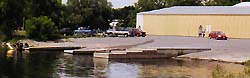
Having a touch of the water gypsy in me I always look for free moorings. There appears to be an unattended wall on the east shore just north of the Price Choppers store ( probably belonging to Price Choppers) if one carries mooring stakes. The space is not posted as a NO MOORING area however there are no bollards or rings on the wall. I would suggest checking with the Manager of Price Shoppers as one picked up some budget provisions. 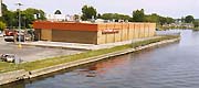
The city shopping area is but 5 minutes walk from the Fraser Park Marina. One of the city operated marinas. All of Canadas major banks have branches here as does one of this countries major food chains. These together with a laundromat, several restaurants and delicatessens are all located on Dundas Street, which is the major shopping area of the town. 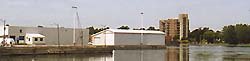
On the west shore you will see a large white building building and old dock. This area is shallow and should be approached with caution. There is however another park and a single launching ramp to the south of the white building. 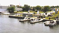
A bit further upstream on the west shore is Fraser Park Marina has 25 transient berths all with 30 ampere outlets and fresh water hookups. The depth of water in the docks varies from 8 to 10 feet but the berths are completely in protected from the elements or the wash of passing boats. There is a dock master on duty from 7 oclock in the morning until 9pm during the season. |
|
MacKie Marine
Phone: 613-968-1993, Fax: 613-968-1996
|
|
J&P Marine Service Phone: 613-962-8422, Fax: 613-962-0956
|
|
Kingston I Amherst Isl I Adolophs Reach I Bath I Pryners Cove I Glenora I Picton I
Hay Bay I Long Reach I Deseronto I Belleville I Trenton I Murray Canal I Presqu'ile Bay |