|
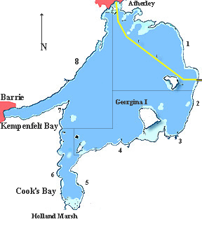
Lake Simcoe is 19 miles long, 16 miles wide making a total area on the order of 325 sq. miles with a shoreline of 144 miles. Lake Simcoe is the largest lake on the Trent Severn Waterway and the fourth largest lake in Ontario. If you are traveling the Trent Severn Waterway it is 28 miles from mile 182.2 where the canal enters the lake on the east shore near Gamebridge to Lock 42. For those of you who have spent a week or so in the canal it is time to put on your seamans hat as Lake Simcoe has few defining shore charistics. Above all it is important to remember that Lake Simcoe is KNOWN for downright scary storms when the wind picks up. Make no mistake, this is not a lake to be triffeled with. If the weather is bad stay put. The size of the lake provides every boater an opportunities. You can find a fishing hole or sail boat racing with enough islands and bays for the less social to wander and enjoy anchoring. |