|
|
|
|
|
|
|
|
|
The Trent Severn Waterway is a huge, well developed tourist attraction and we suggest that you check out the Parks Web site as well. Given a little of extra time we found it almost as enjoyable exploring by car as by boat. All one need do is follow Parks Canada beaver signs which steers you to your favorite Spot Waterway attractions. Most locks are located with easy road access, so you enjoy the locks by land, enjoying boat watching, fishing, picnicking or relaxing in the lock side parks. Geographic Overview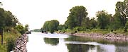
The southern terminus is Trenton accessed from Lake Ontario via the Murray Canal or the Bay of Quinte or running through the Great Lakes. We will not duplicate those pages here as you can reach them from anywhere within Cruising Canada by going to the Lake Ontario Cruising Guide or following the links above. 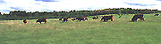
As you start you trip north from Trenton you enter the southern region of the waterway which is quiet rich agricultural farmland with scattered forested areas. In the last of the lowlands before you start to climb you will pass through the Keating Hoard Conservation area and the fragile mile marsh land. Once across Percys Reach from locks 8 to 12, a distance of only 4.4 miles you will start the first big Up climbing a total of 106 feet in the 4.4 miles.
You can get a short break from handling lines at Campbellford and the best priced fuel on the system. If you are using lock tie ups we would recommend you do so above locks 12 or 13 which puts you close to the friendly town. (picture taken looking downstream from lock 13 towards Campbellford) Upstream from lock 13 at Campbellford. In the 3.8 miles to lock 17 at Healey Falls you rise another 125 feet. Further upstream past Hastings you enter the thickly wooded banks of Rice Lake then turning north to the Otonabee River towards Peterbourgh. You will pass partially submerged small teardrop shaped islands and a shoreline spotted with old cottages and resorts. Barely 55 km long, the lower Otonabee river is largely farmland and quite different than type of land you will find above Peterbourgh. Above Little Lake in Peterbourgh the upper portion is characterized by limestone banks and cedar groves where the system cuts north to katchewanooka Lake passing through a beautiful river valley. 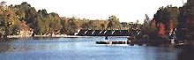
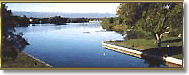
North from katchewanooka Lake there begins a further geological change which slowly changes from the farmland of the Peterborough area to the rocky outcropping of Clear Lake. By Stoney Lake and Burleigh Falls the Kawartha Lakes spread their infinite charm before you. At the top of the Trent Severn, their northern shore lines mark the boundary where the rugged Canadian Shield slides below the southerly limestone. Long established as Ontario cottage country the Kawartha region holds many a day trip and pleasant anchorage beside a rocky island. Working westward through Buckhorn, Bobcaygeon and Fenlon Falls the fingers of the Canadian Shield make their presence felt as you slowly rise to the waterways highest point at Kirkfield. From Balsam Lake you travel northwest downhill through the Carden Alvar to the farmland east of Lake Simcoe. Lake Simcoe has numerous cities, towns and harbours no paragraph will describe their options. For 2002 It is unlikely that we will have a comprehensive section covering this area beyond canal transit. 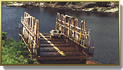
Our journey turns north then west from Lakes Simcoe and Couchiching following the rugged Severn River winding through the Canadian Shield to the north. In the final section lies perhaps one of the largest tourist attractions and certainly a unique experience, the Big Chute Marine railway. You will be over awed by the ease and speed that this system can transfer your boat. Once you enter the lock the operators will position you along a wall then raise the hidden supports from the railway floor. In what appears to be a single move you are whisked along the railway to the next level and sent on your way. From here you are but short distance to the open waters of the Georgian Bay. Natural AspectsFlora The waterway in total spans three of Canada's forest regions. Most of Trent Severn Waterway falls within the Great Lakes -St. Lawrence Forest Region, characterized by a very mixed forest with dominant species of sugar maple, oak, beech, yellow birch, eastern white pine, eastern hemlock, and basswood. The two remaining forest regions are Deciduous Forest or Carolinian in the southern reaches of the Trent River, and the Boreal Forest along the Severn . Alvar conditions looks like poor, scrubby pasture land occur on the Carden Plains to the east of Lake Simcoe in the Kirkfield Lift Lock area. Alvars are limestone plains with little or no soil and sparse vegetation.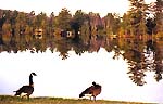 Fauna
Fauna
Within it various forest types a diversity of wildlife such as deer, racoons, foxes, along with forest-dwelling birds. Northern species such as black-backed woodpeckers, sparrows, kinglets, gray jays and ravens occur in the Peterborough area and in the northern reaches of the waterway. Further south you will find the great crested flycatcher and the melodious wood thrush, whip-poor-will and great horned owl. On the Carden alvar near Kirkfield Lift Lock are the less common feathered friends, rufous-sided towhees, grasshopper and clay-coloured grasshopper, and golden-winged warblers and from Canada's endangered species loggerhead shrike. |