|
|
|
|
|
|
|
|
|
Above the lock is a 2 mile long channel which by passes the dam and rapids. There is a shallow area as you clear the cut where you can anchor close off the channel on the east. HOWEVER, this little bay shoals quickly to 3 feet depth. The channel has a 8 foot depth but is narrow with no opportunity to pass. 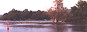
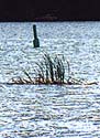
one to two feet. Dont let the locals who dart in to their cottages along the shore fool you, they know where the shallows are. By mile 10 you the chanel runs a bait west of middle as you approach Heagels Island the grass is growing there is only two feet of water here so insure you leave Heagels to your north east side. 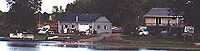
The waterway curves slowley north passing between a set of three small islands which begin at T 64. Once again the weeds growing beside the channel are not fooling. As you reach the last of these islets Rawdon Creek enters from the north. You may notice a collection of smaller boats at the house and large garage in the norther corner, this is River Valley Marine and Sports (613) 395 3035. 
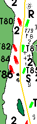
As you clear the south end Danger Narrows a small bay opens to the east where you will probably see smaller fishing boats this area shoals quickley to less than three feet, although there is a deeper pocket directly east of T87 which is opposite a small islet where you can put a hook down if the lock wall is full. |
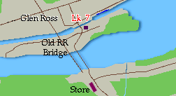
Lock #7 Glen Ross
This is one of the prettier locks which also has access to the Glenn Ross Convience Store which is accross the bridge perhaps a couple of hundred feet. There ae phones here and the store has a good variety of hard ice cream cones. We like it as a stop as the folks are friendly and if you tie up on the east side it is a greay cat recreation area providing numerous grass snakes for them to chase, with only a feline friendly big black dog who routinely visits visiting boats. 
Proceeding upstream from Glenn Ross. Glenn Ross Lock #7 Road Bridge with 3' vertical clearance runs immeadiatly to the south, or upstream of bridge. This bridge is of no concern as it is opened at the same time as the lock with both blue line areas outside of the effected area. Once clear of the bridge, there is a concrete walled channel throug the mentioned nothing land where the down bound blue line on the west side. The entire section is just under a mile in length. At the south (upstream) end of short channel is a railroad swing bridge that I doubt has been closed for many years left in the open position. You have approximatly 11.5 miles before you reach Lock #8 at the west end of Percy's Reach. |