|
|
|
|
|
|
|
|
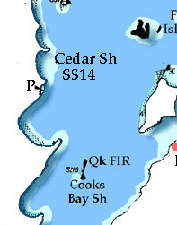
Directly north from Big Cedar Point there is a bay with the community of Alcona which has no facilities except for a public launch ramp with 4' of depth on the north side at Innisfil Beach near the point. There is no reason to travel to close to shore in this section of the lake as there are no facilities between here and Big Bay Point. There are however 2 shoal areas with shallow water which are Cedar Shoal marked by SS14 then The Ninth Shoal marked by SS12 which has a rock close inshore from the buoy. If approaching from the lake the is a privately maintained light situated at Q Occas 44.9 miles south of Big Bay Point mid way between the shoals. When traveling to or from Cook's Bay we recommend that you allow yourself .75 mile of distance from the west shore and pick up a heading of either 185°T headed south or 005°T if you are traveling north toward Big Bay Point. The distance between Big Cedar Point and Big Bay Point is a little over 7 miles. You do not want to stray too far offshore as this course will take you to the west of Long Shoal with its rock and 3' depths and lies 22.3 miles SSE of Big Bay Point offshore. It is marked by SS9 and SS11 which can be difficult to see, by following this course you can avoid the worst of the waves caused by prevailing winds. Big Bay Point# w data source is official fisheries & Oceans Big Bay Point is a sharp finger of land that marks the beginning of Kempenfelt Bay from the southern section of the lake. 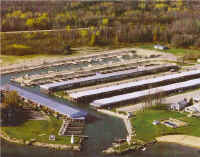
Roughly a mile south of the point is Big Bay Point Marina (16) (705) 436-1176 Big Bay Point Marina web site Big Bay Point is another of the Lakes sophisticated marinas with extensive facilities. You can not miss them as the two substantial lighthouses with privately maintained flashing red and green light that flank the entrance. They do have space for 20 transient boats as well as seasonal customers with 6' of depth and up to 50' length. photo by Big Bay Point Marina The marina has 350 season docks which offer a variety of levels of service. Facilities include 15, 20, or 30 AMP power, washrooms, showers, laundramat, a 35 ton travel lift, 12 ton fork lift, engine, hull, electrical, propeller repairs, a well stocked marine store. This place has a lot to offer as a destination beyond the dock. There is a B & B, picnic areas, playground, recreation, swimming pool, tennis courts, beach, fitness facilities. For relaxing there is Blondies By The Bay offering lunch and dinner menus with a patio and entertainment. Kempenfelt Bay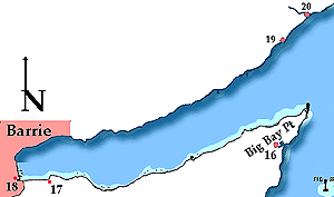 Kempenfelt Bay is a 9 mile long finger of water that leads west terminating at the City of Barrie. There are no surprise hazards here with water depths often over 100', the shores tend to be wooded with a gravel shore. Proceeding west on the north side of the bay is Gull Rock Marina (20) (705) 487 2805 easily identified by it Shell sign offers no transient facilities. You can get gas here and they do repairs to both engines and hulls. There is 5' of water and they can deal with boats up to 33'. There is a public wharf on the south shore .6 miles west of Big Bay Point with an elevation of 2.5' and a length of 174' with depths from 4' to 9'. On the north side of the bay, in Shanty Bay there is an other public wharf having an elevation of 3' and a length of 105'. Depths are 5' to 6'. Further west on the north shore 1.3 miles you will see a private dock with a white lighthouse structure of 30'. On the south shore .6 miles east of Lovers Creek is another wharf with an elevation of 2.5' and 52' in length and depths of 5' to 7'. On the south shore close to Minet's Point is Brentwood Marine (17)(705) 722 8344 the have gas, and do repairs but no overnight dockage. There is a small store and they have a 20 ton travel lift for hauling boats to 40'. Back on the north shore is Deep Point which is followed by the Barrie Yacht Club. This brings us to Barrie which is a major city with all attendant facilities and services. At this time I we will not try to describe the city facilities of features as the city has an extensive web site which you can explore yourself. City of Barrie web site. City of Barrie Marina (16) (705) 739 4218 does offer transient facilities. They have 7' of draft and 60' length available for visiting boaters. There are in fact two marine areas the Bayfield Street Boat Basin to the north with a large concrete pier having a elevation of 4' and length of 280'. Depth away from shore will reach 12'. To the south is the City of Barrie Marina. Your entry is between the break walls before making a 180° turn into the basin its self. At night there are two yellow lights that create a range to assist your entry. This is a typical city marina with limited amenities at the marina other than a launch ramp, showers and gas. |
North West ShoreProceeding north from Kempenfelt Bay once past Oro Beach the shoreline stretches in a generally NW direction past Parkside Beach which has unmarked Oro Reef located roughly .5 miles off shore with depth of 8'. When coasting north here watch for Hawkstone Shoal marked by red (SS8) not far off the point. Hawkstone has a concrete public wharf having an elevation of 4', and length of 165', depth average around 3'. There is also a launch ramp at this location. Hawkestone Yacht Club (HYC) (705) 487 2700 web site can be found 2 mile west of Eight Mile Point. on of the two groynes that mark the entrance to the harbour. Your entry is from a northerly direction, with a bright orange light at the shore behind the south groynen and a fixed red light within a light house behind the north groyne. Facilities are pretty with room for 65 boats secured stern in a secure cove. . The club has a 3 story clubhouse, private beach, 30 AMP power, showers, BBQ's and can accommodate 5 yachts with reciprocal privileges. For supplies the Hawkestone General Store is a short walk away. If you follow the shore you find Cathew Bay which lies west of Eight Mile Point and has a floating dock with an elevation of 1', and 79' long, depth along side is approximately 3' close to shore with 7' at end. . There is also a launch ramp at this location. Cathew Bay is normally well protected from prevailing winds but exposed to the south and south east. Depths within the bay average 20'. THe outs side of Cathew Bay is formed by Eight Mile Point roughly 8.3 miles to the north east of Big Bay Point. When approaching this area of the lake at night CAUTION should be use as a privately maintained light, which is not always lit, yet conforms to standard criteria thus may cause confusion. This light is located on private property on Eight Mile Point at a position identified by Fisheries and Oceans as 43° 31' N 79° 25' W.Four miles NNE of Eight Mile point close to your course to or from the Narrows is the rock and sand Whitefish Shoal marked by red SS2 and having 4' of depth. Five miles to the north of Eight Mile Point is Shingle Bay which has Shannon Bay to the NE.
Gape Island Fairway Light ST is found midway between Champlain Point and Grape Island within the approach to Atherly Narrows. |
|
Lake Couchiching South . SH Channel . SC Channel . North to Lock 42 |