|
|
|
|
|
|
|
|
|
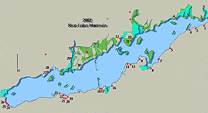
Cameron Point to Indian River
The north shore of Rice Lake from the east.at Cameron Point to the west at Indian River is approximately five miles distance. The surrounding farmland stops short of the lake giving way to a mostly wooded shoreline which does not have a lot of facilities available for larger boats. Beginning coverage of north shore facilities from the estuary of the Ouse River where it joins the Trent River, draining Rice Lake eastward downstream . 
On the north shore opposite Morrow and Webb Bay is Holiday Pines Three Seasons Estates. You cannot miss the trailers which stand out tier upon tier . (2) Cameron Point marked on charts with the Cameron Point Marina. Separated by the estuary of the Ouse River is yet another trailer park
Located .6 miles west of Cameron Point is (32) Birdsall Point. There is a grassy shore immediately to the east of the Public Wharf. The wharf itself is a single floating section which has a small breakwater to the west. Depth as reported as 5 feet along the outer portions of the dock but there are no facilities other than a gravel launch ramp at the dock itself. There is the Birdsall Beach Camp ground not far up the road. The trailer park had phones, camping, picnic facilities, groceries, bait and tackle. Proceeding west, Rice Lake begins to widens out with few obstructions along the north shore. Approximately 3 miles NNW of Birdsall Point lying 0.2 miles offshore is Lower Foley Island. Another 0.8 miles beyond is Upper Foley Island, both islands are heavily wooded. (6) Elmhirst's Resort (905) 295 4591 is on the mainland 0.3 miles NNW of Lower Foley Island. The resort maintains a smallish dock to the west of the playground and beach, with depth of 4 to 5 feet they can accommodate a couple of boats but have no breakwater to protect them. They have the basic transient fare with 15 amp power and water. However ashore the facility offers numerous recreational options for the visitor, as included in your mooring charge is full use of the facilities and an inclusive kids programme. The list is extensive including a whirlpool, pool, fitness equipment, tennis, volleyball, basketball and baseball, convenience store. For the family they have two licensed restaurants.
To the west of Upper Foley Island on the mainland is Foley Point 44 ° 14 N 78 ° 04 W on the eastern side of the Indian River delta. The Indian River enters Rice Lake to the north of Sugar Island leaving a shallow area stretching from Foley Point to the east all the way to Roach Point at the west. Sugar Island which is heavily wooded is located in the middle of the Indian River. Any large cruising boat will do well to use caution as depth averages 4 to 6 feet throughout the area. The Indian River is often choked with weeds and is shallow although there is a locally known channel to the NE of the island which has a depth of 3 feet. For small boats it is possible to venture a little less than 2 miles north to Keene. In Keene, with less than 400 population The Indian River Lodge is on the west side of the river below the bridge. They offer cottages, rentals, tackle and fishing guides. Roach Point located on the west bank of the Indian River as is (11) Serpent Mounds Park.The park itself is managed by the Hiawatha First Nations. Serpent Mounds is unique in Canada, very similar to some of the Hopewell Indian earthworks in Ohio. Unfortunately for most waterway users there is only 2 to 3 feet of water dock side. If you can reach the dock there is a self guided tour which explains the site along with a souvenir shop. Your day use fee covers the exhibit cost. North of Serpent Mounds. almost entering the Indian River, are two smaller cottage and fishing resorts with little for the visitor. (10) Anglers Retreat (705) 295 6837 does have 6 feet of water dock side and can occasionally provide transient dockage. Almost next door and easily spotted by the GAS sign to the west is Whispering Pines Cottages (701) 295 6857 which has 3 foot along side the dock. To the west of Roach point is McGregor Bay which is only accessible from the east as shallow water and weeds join the string of islands to the west. The islands begin with Rainy Point Island which is furthest east almost due south of Roach Point. There is no passage and little water between Harris Island and Prickley Point Island which almost touch the mainland at Plumb Point on the west side. Located on the west side of McGregor Bay is McGergor Bay Marina (705) 295 6697. The noticeable feature is the floating white building and flagpole. They are open weekdays and weekends during the summer, providing outboard repairs common parts and a variety store.
Roach Point to Picnic Point.
CAUTION there are old RR bridge footings crossing Rice Lake from Harwood on the south to Picnic Point on the north shore. There are numerous places a person with local knowledge can slip through other than the channel but this is definitely not recommended. You can easily see the Hiawatha United Church spire 0.5 mile west of Picnic Point. The Hiawatha Tent & Trailer Park (705) 295 4421 is a First Nations facility with dockage for boats of 2 to 3 foot draft. For the bigger boat you are better to consider the old government dock, however there is still only a couple of feet. You can find the old government wharf slightly east of the group of TH buoys marking the north end of the old RR bridge. Rice Lake North Shore - West of Otonabee RiverFrom Bewdley east along the north shore, all the way to Halls Landing there is nothing for the non local. There are the now familiar cottage resorts and small fish boats. You are nearing the mouth of the Otonobee River entrance before reaching Halls Landing. Southview Cottages (705) 939 6761 which offers transient dockage with very good depth. Service facilities are limited to 15 amp power and potable water at the head of the dock. Otonobee River EntranceWhen approaching the entrance of the Otonobee River from the lake. CAUTION You must approach from outside the FIR and pass between the navigation markers T 433 T434. UNDER NO CIRCUMSTANCES try to cut corners otherwise you have it all awaiting you, mud, weeds and rock. Trust us stay between the marks. |
|