|
|
|
|
|
|
|
|
| ID | Mile | Kilometers | lift | length | Sill Depth | Preferred side |
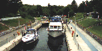
| # 42 | 210 | 338 | 21' | 155' | 7' | Starboard |
From Couchiching to Port Severn you will be traveling a part of the waterway who's course was finalized in 1913 and completed in 1920. During the non-peak waterway season this trip can be completed in less than 5 hours. During the high season you can easily add 2 to 4 hours to this transit time due to a backlog at the Big Chute Railway. 
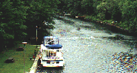
Your visit to Lock 42 can be a release if you have been headed north as you have just managed to brave the highest volume of traffic you will have to face. The lock and the surrounding area is very rural with a few houses set back at the top of rather high banks. Above the lock is peaceful with considerable space to tie up. There are picnic tables and wash rooms within this wooded section. 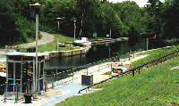 Your course course from Lake Couchiching will begin by passing through the Couchiching Conservatory often flanked by high cliffs and punctuate by well policed speed controlled sections. Close above Lock Couchiching you will join the Severn River for a distance of 4 miles until you reach Sparrow Lake. Much of this leg is unmarked with the channel holding a good depth to close to either shore. Below Lock 42 you join the Severn River. If you wish to visit Severn Bridge this is your opportunity as you have a 1.7 mile stretch of navigated waterway to Severn Bridge. You have no overhead restrictions until you reach the highway bridge in Severn Bridge which has a vertical clearance of 9'. There is a government dock below the bridge and there are facilities close by. Severn River Inn (705) 689 6333 has transient dockage for a half dozen boats with vertical clearance of less than 9'. There is a concrete wall you can tie up to as you check in at the desk or on the patio. It's a pretty good stop if you want to spend shore time as there are several restaurants and fine pub. Perhaps a mile away on the north side is Art's Recreational Repair (705) 689 8194. They handle repairs to fiber glass and engines if you can make it under the bridge there is plenty of depth at the dock You will pass a one buoy S256 at mile 211.5 and just over a half mile ahead the river will to starboard. The channel through the curve is marked by S254 and S253 followed quickly by S252 and S251. The picture below is looking upstream from the swing bridge.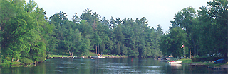
As you clear the turn begin to look for day marker S249 marking the beginning of a short section where the channel winds its way past a few hazards, S248 and day mark S246 mark a small island to port and then S244 and S243 set a course to avoid the small rock / island to starboard. 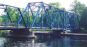 SWING BRIDGE - Hamlet Road Bridge 57
Chart 2029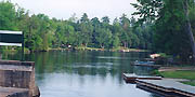
A small community called Hamlet lies about 2.5 miles from the lock and is identified by a swing bridge crossing the canal at this point. The community is comprised of well kept cottages and a few small resorts set back from the waters edge. a public docking facility is located on the west side, close down stream from the bridge. This is an abandoned jetty and is often used for locals fishing with facilities some distance away. 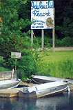
On the east side above the bridge is Idylwilde Resort a small cottage resort with several small fishing boat docks. Unlike many cottage communities along the waterway Hamlet occupies a neck of land that much of the transport throughout our history has flowed. The Hamlet, its self shares the neck of land not only with the 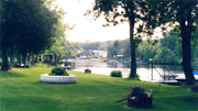 For the transient boats please remember this is a SPEED CONTROL ZONE. For the transient boats please remember this is a SPEED CONTROL ZONE.

To the west the canal is bordered by a road while the east side has a beautiful park along the shore while the cottages are set back in a neat row. The upstream canal enters Sparrow Lake near the its south end. immediately north of the entrance is Monahan Point, which the isthmus created by the canal and headland separating Welsh Bay is taken up by Lauderdale Marina. If you have problems with your smaller cruiser you can find Sparrow Lake Marine (705) 689 9806 right in the village of Hamlet on the populated side of Hamlet. They can haul boats of less than 30' and offer emergency mechanical repairs to gas engines and props. If you wish to wait for morning to cross Sparrow Lake of head up to lock 42 there is a marina at the entrance of the Severn River to Sparrow Lake. You enter Lauderdale Marinafrom the canal side staying between the white buoys. 
When approaching the canal entrance and the marina from Sparrow Lake one should exercise CAUTION: as there is a shoal extending outward from the point into Sparrow Lake.It is marked with unpainted poles and privately maintained markers but may be hard to see in poor weather. |
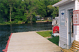
(705) 689 1800 Phone: 705- 689 - 1800, As you approach Sparrow Lake from upstream the Lauderdale Marina is on port. The entrance channel is dredged and bulk headed with a boardwalk along the edge of the gas dock. 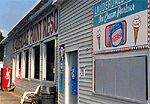
There are several large grey buildings and a number of lower structures. The marina is well lit at night and you can see their flag poles from some distance off. There is a Petro Canada sign at the fuel dock. There is a snack bar and convince store at the gas dock with video amusement for the bored member of your crew. 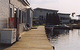
Depth in the marina channel has at least 6' of depth all the way to the fuel dock. The marina can handle boats up to 50' in either covered or open slips.
|
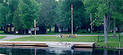 waterway, but the rail line and two main roads leading around Sparrow Lake. Railroad track lie to the west of the waterway separated by a gravel service road from the west bank of the river. While on the east side there is a charming waterside park along most of the east shore. The cottages are set back separated by a road.