|
|
|
|
|
|
|
|
For a complete explanation and diagram of how a lift lock works check out the [ Locks and special feature page here ].
|
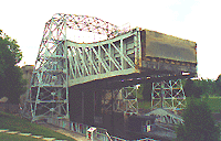
The Kirkfield lock, ahead, is the second lock of its type on the system, it is similar to its big brother in Peterborough. The lock is not quite as high and much of it is fabricated from steel, unlike Lock 21 which has concrete towers for the lifting structures. There is a long wall leading into the lock and like Peterborough Lock there are control lights to signal when to enter and which side to use. Again, at this lock you tie off on the railings and make your vessel secure for the descent. You are exposed to north west winds. Have a camera ready, the view out over the country side is spectacular and you will likely have some time to look around as the Lockmaster loads and prepares the lock for the transfer.
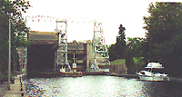
There are long walls below the lock with plenty of room for a large number of boat. Although this is a beautiful spot there are no shore facilities other than washrooms up the hill in the visitors area. If you want to eat out there is The Lock's Nest Restaurant on the road passing through the lock and serves home cooking, on County road 503 which runs through the lock structure that has a small store next to it. 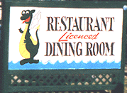
From here to Lake Simcoe there is not much to talk about, it is pretty much a ditch with one exception of Canal Lake. West of Kirkfield there is a speed controlled zone is in effect until you reach mile 170 at Canal Lake which is perhaps a half mile west of the lock. Canal LakeCanal Lake is artificial in so much as it started life as Grass Creek before the waterway flooded it. The lake is made up of two portions divided mid way by an island joined by county road and bridge. Headed west toward Lake Simcoe the east portion requires extreme vigelince as the entire area is foul with submerged or often not so submerged stumps and trees. There is a set of burbs to the north of the channel when you first enter the lake at its east end. A new buoy series "S" has started as you enter the lake at begin with S 409 to the north and S 410 on the south. THe channel follows the south which is lined with cottages. 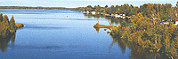
At mile 172 you will begin to enter a narrow area where the island slowly infringes of the lake as you approach the bridge. By S 385 & S 386 the bridge and its earth burbs reach east toward you. There is a the rather large Centennial Campgrounds on the east shore of the island. There are no facilities for transient boats here and the water is too shallow for anything but small fishing boat. However for the fisherman with a camper this lake will be a good days fish. 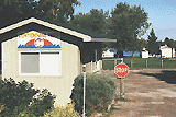
The channel is crossed at mile 173 with the Canal Lake bridge having a clearance is 28' no speed zone is indicated on the chart but I would slow down through the bridge area due to the burbs on each side. 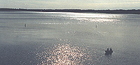
The west half of the lake is a little more open and deeper with roughly 10' depth in most of it. for the transient cruiser this is not a place for you, leave it to the fish boats and their fishermen. At the west end of Canal Lake you are funneled between S 368 & S 369 into a narrow channel that bends westward just enough to obscure what is ahead. You are almost upon the 43 Bolsover Road swing bridge be prepared to mark a little time as the bridge has a normally closed position and you may have to signal for an opening.
As you exit the bridge watch for a 3' shoal located down stream just below the Bolsover Bridge on the south side at S 364 in spite of the tempting looking little bay formed by the creek. You are in the Trent Talbot River now and canal winds its westward for another 1.5 miles to the Boundary road swing bridge.
Bolsover Lock 37 is now within site dead ahead. |