This information is not for navigation, always use official Hydrographic Charts
|
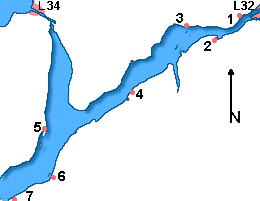
Sturgeon Lake is boomerang shaped with each section roughly 9 miles in length. The east end of the lake is Bobcaygeon while the norther end of the west arm leads to the Fenelon River and Fenelon Falls, while the southern tip of boomerang V is the entrance to Scugog River which leads south terminating at Lindsay which will take us a while to complete as our draft was too deep to explore the area. Although the lake has deep water close to shore the most important thing a local will tell you about the lake is that even after all the years each winter, or storm a new batch of long submerged stumps work free and surface. However, Sturgeon Lake over its past years the lake became popular as a get a way for city folk who built some impressive cottages, if one can call them that. (we have quite an impressive gallery of fabulous one which will appear later in the site development) Along with the cottages came sailing events and in the heyday of the Kawarthas the steamers plyed this lake extensively. Departing Bobcaygeon headed west there is speed control channel extending upstream for about 1.25above the lock. There is also an area to the north of C 361 and C 362 which is too shallow for most cruising boats. For larger craft there is bay south of C 363 and C 364 suitable anchoring with limited dockage at the town docks l on the south shore here. Stick to the channel until clear of C 373 and C 374 The waterway remains fairly narrow to Cottage Point located 0n the north shore at mile 139. Little Bob Channel turns east back to Bobcaygeon south of the waterway. It is not navigatable with a vertical clearance of County Road 24 low bridge with a clearance of only 2 ft . 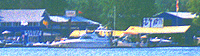
At mile 139.3 on the north shore is Center Point Landing (705) 738 3463 which provides substantial facilities for larger cruising boats. The shorelines recede and there is a clear set of channel markers towards open water. There is a private channel the south leading into Birch Point. Birch Point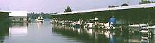
The channel narrows off Birch Point and is identified by C 385, C 384 and C 386 which then reaches open water. On the south shore just east of Birch Point is Birch Point Marina (705) 738 2473 the marina has a well sheltered harbour with land fill burbs. You can see the covered slips tucked behind a modern office waterside with good facilities, with a large black and white sign. There is adequate water here for most boats on the Trent Severn as they maintain a dredged channel of 5.5 feet and can accommodate vessels up to 37 feet. 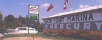
The east section of Sturgeon Lake is 10 miles long, averaging between 0.5 to 1.5 miles wide. Deeper draft vessel should take notice that there are hazards near the shores of Muskrat Island marked by C 388, a 6 foot shoal close south of the red buoy 142, and at mile 141.9 near McConnell Island C 390, C 392, & C 394 above mile 142.9 the lake is wide open. 
North of Muskrat Island located in Hawker's Bay is Eganridge Golf & Country Club (705) 738 5111 identifiable by its green roof and a small white sign. The club offer gratis berths for those using the facilities and further tempts the visiting cruiser with a European restaurant operating 7 days a week in season. They maintain up to 12 transient slips As you might expect service is a keynote her and if you wish a shore break pick up the phone dock side and someone will come and deliver you to reception in a golf cart. 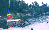
Located on McConnell Island's N.W. side is Verlam Park which has a concrete wharf with 3 to 5 feet of depth. There is a swimming area, washrooms & picnic tables, but no overnight mooring. From McConnell Island you upstream course will be roughly 234 and follow the markers CBK and CBS down towards Sturgeon Point. Ashore at mile 146 opposite CBS is Greenhurst-Thurstonia which is another cottages community with substantial a T shaped concrete dock that provides a gravel launching ramp and excellent day stop for smaller boats with roughly 4 feet of depth at the outside of the dock. 
To the west of Greenhurst-Thurstonia on the south shore is McLarens Marina (705) 793 2282 . You can't miss the mini lighthouse at the end of their dock, or the galvanized roof of the covered slips and faded grey paint provide a deep water stop for transients as there is a good 8 ' of draft available if you are under 30' LOA. The sign is weathered and facilities more suited to the fisherman than the cruiser. The only shore side entertainment is a restaurant and grocery store within walking distance in Dunsford. 
McLarens Marina has limited shore side space crowed between the road and the lake. The entire shore here has cottage docks and small boats so be considerate when approaching from the lake. 
The lake remains open as you head down towards the channel junction near the bottom of the lake. Off on your starboard side, the C 396 buoy marks a shallow hazardous area close inshore near the south shore of Sturgeon Point. Due south of mile 148 is Pleasant Point with a concrete dock parallel to shore. 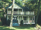
To reach Fenelon Falls the main channel rounds Sturgeon Point and follows the west arm of Sturgeon Lake for 5.5 miles. Sturgeon Point on the north shore is a long established cottage community with lavish homes. There is a public dock and small beach here however its proximity to the channel and lack of any protection from passing boats wake make it a risky place to tie up. There are many private docks here many looking more inviting than the public dock but they are private. The photograph is looking east along the east arm of the lake. 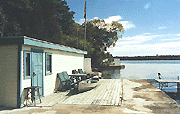
IF you wish to follow the main Trent Severn Channel North of Sturgeon Point you need ot exercise CAUTION as the Channel markers now cary "N" identification. IF you are not interested in the south shore or the Scugog River click here to continue north Fenelon Falls and Lock 34. On the south and west shore, perhaps more of interest to those headed into the Scuogg River continue reading.
Sturgeon Lake Marina (705) 739 1176 is located on the south shore opposite Sturgeon Point mile 147.5 in Kennedy Bay. If approaching late in the day or night there is a flashing orange light which is easy to spot. The marina is run by a delightful couple and kept as neat as a pin with space for up to 8 transient vessels with dock side depths of 4'. 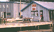
The seasonal vessels tend to be smaller or houseboats with both covered and open slips. There is a small store with supplies and fishing boats to rent with promising & productive fishing holes close by. They can haul boats of up to 25' with 15 amp power, washrooms, showers, picnic tables and parking close to the slips along with e-mail. The bifurcation buoy CP, flashing Green in a 2 . 1 sequence. The main channel to Fenelon Falls, or to the south leads to Lindsay, Lake Scugog and Port Perry. Located on the west shore at Long Beach there is a public dock flanked by two marinas. The dock is a "L" shape with its main length parallel to shore. Mac's Marina (705) 359 1121 is found here with 5' at the gas dock and haul out via trailer of boats to 30 feet. They have rental boats & cottages, with 15 amp power and a johnny on the spot. Further south on the way to Scugog River on the south shore there are three more facilities which we will mention here as well as on the Scugog River pages. West of Sturgeon PointThe fairway markers NSA mark your course with a string of g green buoys N 1 to N 9 to the south of the channel, N 10 and N 12 mark the beginning of your turn into the Fenelon River at N 13 & N 14. There is little in the way of facilities along this stretch until you reach the Fenelon River and Wychwood Lodge and Cottage Resort just before you enter the Fenelon River proper. We will discuss their services as part of the Fenelon Falls page next. CHART GROUP 2026Scugog River & Lake ScugogWe will be somewhat redundent here and discuss the southern portion of Sturgeon Lake up to the entrance of the Scugog River here as there are two larger marinas accessible via a narrow channel which follows the south east shore. This is a section which may not get completed before the 2003 season because of the draft restrictions. The first is The Moorings at Snug Harbour (705) 324 6667 is roughly a mile to the south of Point Pleasant and is home to a substantial number of larger power vessels having less than 5' of draft. THe marina entrance is close off the buoyed channel and just south of the small island. with 80 berths for up to 40' LOA. The marina is a substantial facility with a 7 day mechanic during the season along with a stock of props and parts . THey have 30 amp power, swimming pool, hot tub, covered slips picnic tables BBQ's and convenient parking close to the seasonal slips. 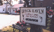
Lunge Haven Cottages (705) 324 6610 is further south on the Scuogog River route slightly north of mile 150 (en route to Lindsay). The gas dock is close to the channel and the large GAS sign is clearly seen from the channel. They do have limited transient dockage for smaller boats up to 25' and 4.5' draft. There are showers, water, 15amp power and a beach combined with a small store.
|