|
|
|
|
|
|
|
|
|
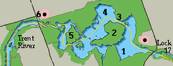
Your crew can now relax for a while as there is 15 miles before your next lock at Hastings. The captain cannot however relax as the route passes through shallow, foul ground, stumps and various other evils surrounding the channel which changes width quickly at times. Oh yes I forgot to mention the local fishermen or urrrgh enough said. Pretty much this entire area is excellent fishing country with several resorts. Just when you think you are doing well you are likely to find a small boat traveling at high speed directly at you from around a blind corner. After you pass under the highway bridge at Healey Falls, entering Seymour Lake your course angles north west, past Kellers on the north shore and cuts close to the marshy point at Woodland where there is a the Woodland Trailer Park (705) 653 1317 but it has no transient facilities. North, around the point, on the same shore is Fishermans Paradise (705) 653 1537 another cottage and trailer resort. The docks here are seasonal and the small store caters mainly to local fishermen with 2 to 4 feet of water available at the dock side. 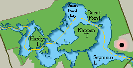
Angling north west again you will pass between the north shore of Nappan Island and Cedar Island into the Northumberland Narrows which is formed by Nappan Islands north shore and Burnt Point on the mainland. Clear of the narrows you enter the top end of Burnt Point Bay where you make a sweeping turn, leaving T293 to your south, to end up on a south westerly course down the bay. For smaller day boats there is The Red Setter Resort (705) 778 3096 located at the north end of the bay with 3 feet of water and privately maintained buoys marking the best channel. They do have 30 amp power, showers and normal camping facilities. Alongside Red Setter is the private Princess Houseboat Rental (705) 778 7317 an operation which will take several transient boats when space is available and has at least 4 feet of water dock side with 15 amp power outlets. 
Your course south west through Burnt Point Bay carries you to the south of a small islet off the SSE tip of Long Point leaving, T297 to your south. For the next three miles your course is serpentine, wending its way between the tiny islets of Mink to the north and Gark to the south, then ducking north close to Dunn Point. We have successfully anchored a 50' Spray in the deep water to the north of T304. As you follow the markers around Hardy Island, swinging slightly NE to round close to the north shoreline opposite the north tip of Graham Island at T322. Cottages line the shore as you enter the SPEED ZONE of Trent River, most have docks small boats and the residents are likely to be watching, so keep the speed down. If you need fuel don't bother with the marina sign on the north shore at mile 43 it is long closed. 
Clearing the last bend before the Highway 30 bridge (clearance 22 feet) you might watch out for the prominent white pillar of the War Memorial on the south bank at Dope Point just downstream of the bridge. There is a long concrete government dock extending into the river with 8 feet of water, half way out and each time we have passed there has been space to tie up. There are no facilities, but a short walk across the bridge is the Trent River General store which has groceries, ice and pay phones. 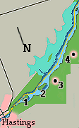
Upstream of the bridge you are clear of the speed zone and most obstacles with approximately 5 miles before you reach Hastings, should you wish to make some time. The river makes a sweeping bend back to the south west with plenty of water midstream. As you notice the overhead power cables watch for T335 to the south marking a rocky shoal. The channel runs north of Steam Mill Island which has a shoal at its south end, marked by T339. 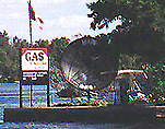
To the west the shoreline noticeably gives way to a wide marsh which will accompany you for much of the next few miles. On the south shore at roughly mile 47 is Friendly Acres Resort, not far from Westview, slightly inland. The marina looks well kept and quiet with space for 7 to 10 visiting power boats of 4 foot draft. There were a large number of rental boats at the dock and a nice looking beach. There are several different stores as well as numerous recreational facilities. The run here is very peaceful with an active marsh teeming with wetland birds. From the numerous ingenious blinds that line the small inlets you can be certain the duck love this place on the fall journey. 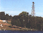
The marshy area gives way to a wooded hill as the channel narrows when passing north of Huycke Island. You do not want to stray from the channel in this section as there are rocks close at hand with 3 feet or less of water over them at several places. ( CAUTION T343-T345-T347 south of channel, approaching and close off Huycke Island) 
You follow the north shore cutting south to the north end of Preston Island. (CAUTION north of channel passing Preston Island at T356-T358 rocks awash.) Hastings Lock #18 is right downtown and a favorite stop. When we stopped we stayed below the lock as it was further from the park like area above and Edgar likes to fish, swearing below lock is better. The lock itself is on the north side of the river with a highway bridge at the upstream end. The road bridge above the lock is operated at the same time as the lock as there is only 5 feet of clearance so that the bridge is no problem. 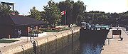
We in fact spent a couple of days in Hastings this last time having ended up there on the fated September 11th, which gave us a chance to get to know the town a bit. Rather than take up space here we will give Hastings its own page here. |
| ID | Mile | Kilometers | lift | length | Sill Depth | Preferred side |
| # 18 | 51 | 82.3 | 9' | 155' | 8' | Starboard |
| Area Code | ( 705) | |
| Police 1-888 | 310 1122 | |
| Chamber of Commerce | 696 3226 | |
| Municipal Office | 653 1900 | |
| Lock #18 Phone | 696 2864 | |
| Hastings Marine | 696 2366 |
| 44 ° 18.52 N | 77 ° 57.23 West |