Admiralty IslandsClick on most picture thumbnails for a full size image |
Admiralty IslandsClick on most picture thumbnails for a full size image |
|
The Admiralty Islands have long been built up as a cottage resort with many islands having cottages hung off a rock and boat dock below. 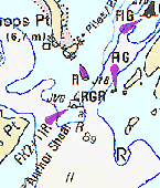
We will begin our cruise of the Thousand Islands from the Bateau Channel where the cable ferry crosses between Gillespies Point and Bishops Point. There is accommodate of water in the channel however, it is tight if there is a lot of traffic, since directly east of the points is Anchor Shoal. It is a good idea to lay your sail plan for the day before you start out, since this marks the turning point for you destination in the Thousand Islands. 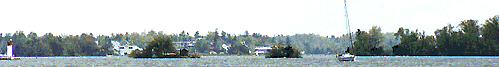
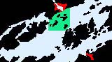
Should you choose to visit Gananaque you will first turn north-east rounding the buoys and leaving Beaurivage Island to your starboard. Watch for the markers in the distance as you head for Gananoque in order to avoid Spectacle Shoal, shown to the left (west) in this photo . If you wish to spend time in the Admiralty Islands or continue to the Lake Fleet Islands your course will take you roughly south-south-west from here. Whatever you choice, there are plentiful anchorages nearby. click for large scale map of Admiralty Island Group 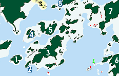
|
|
For those interested and wishing large scale graphics, these are available for subscribing members only due to downlaod costs. Wanderers Channel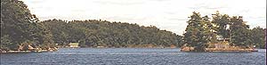
This is the view of the southern approach to Waunders Channel viewed from just north of Mermaid Island. Wanderers Channel is entered when NE bound for Gananaque, beginning between Mermaid and Aubrey Island and the northern part of the islands and winds between the Admiralty Islands. the channel here leads to the west of the large house which sits mid channel. Aubrey IslandViewed here from Bishops Point, from right to left the islands are Aubrey then Mermaid. 
One of the first public islands in this group is Aubrey Island which is situated furtherst west. The most noticable feature as you approach from the south is the large square red marker located on it's southeast corner. There are three places where you can dock on Aubrey. 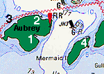
Perhaps the most romantic is in the bay located on the 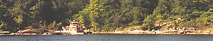
The picnic shelter, toilets and campgrounds are to be found close by. The usual peremiter trail provides access for exploring and you might search out the ruins of the late 1800 lighthouse and light keepers house, toward the NE tip. The primary access to the island is on the northeast face ( 2 ) and is a concrete structure with floating fingers. this is where most cruising vessels head for however was constantly full during the entire time of our visit. Outside there is fair depth on the outside, having had 8 to 10 feet, while the inside has only 4 or 5 feet. The water is clear but do not take chances as there is a large boulder which is awash on the approach. The small dock is for park personnel, again . The most secluded spot is found on the north side where a couple of boats can get in providing they have limited draft of 3 to 6 feet. It is away from the main channel and the powerboat wash. I would say that the 3 feet is the more accurate depth and we did not attempt a landing here. |
Beaurivage Island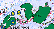
If you need a place to stop after a passage from the west this is probably your best bet. Beaurivage is a roughly H shaped granite island with little topsoil, but it is very pretty. The foliage is oak and pine and is a favorite with locals. the bays formed by the H shape of the island provide shelter from wake and have considerable dockage for the islands size. 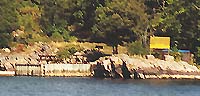
The west bay ( 7 ) will accommodate 6 to 8 cruising boats with up to 8 feet of draft on the dock located on the south shore. You should pay attention to the shoal marker on the eastern side of the bay as you enter the bay from the channel as it is almost in a direct line with the dock. The shallower bay is situated on the east side ( 6 ) and suits power boats of just over 3 feet of draft. You will fnd the docks on the north shore with a small section on the southern edge. When you go to search out the facalites you will find them on the north section. 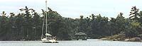
The water between ( 5 ) Lindsay Island and Beaurivage Island is a favorite that somehow the hydrographic service was too cautious in sounding. You will find 6 to 7 feet there and with the exception fo the occasional wake ( see wake ) it is ideal. There is a dighy ramp located on the rocky shore for anchored vessels. 
There are lots and lots of weeds to contend with so do not be complacent with a 30 lb. Dan forth, get something down that will hold. However DO NOT PASS between Linday and Beaurivage to reach the Wanderers Channel, there are power cables which must be avoided. There are a couple of other options which are a floating dock with 3 or less feet along the south side, but they are calm and sheltered from wake. The deep water docks for deep keel boats lie to the north bot experience considerable wake. There are many private islands in the Thousand Islands so please remember but stopping to ask directions is a no. The more tempting large islands which are private and have no public access in the Admiralty group are Bostwick Island, Tremont Park Mermaid Island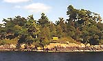
Southwest of Aubrey the smaller Mermaid with its windswept pines and crags are a testimony to the prevailing winds providing a brisk vantage point to enjoy the southeastern approach route. The island is granite and quartzite and shows the wear of the ages since the glacial age with its ragged west end smoothing to the gentle roll to the waters edge. 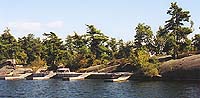
The docking at Mermaid /Island ( 4 ) is quite deep but rocky and uneven so pick your way in with someone on the bow. The docks however are as sophisticated as anything in the islands. It is however worth noting that there is a lot of space available and the layout lends itself to secure moorings for at least 4 to 6 boats. When exploring it is worthwhile to let you know it is home to some decent sized water snakes but they have no interest in biting you, only in catching their fish dinner.

On the subject of wake.
|