www.cruising.ca Navy Islands Canadian Hydrographic Charts 1437 |
|
www.cruising.ca Navy Islands Canadian Hydrographic Charts 1437 |
|
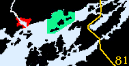
Located close to the Canadian mainland the Navy Islands are somewhat different than the more southerly islands, in that the water around them tends to be shallow. 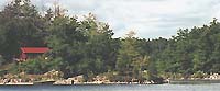
We will begin our tour from Ivy Lea. The north end of Lancaster Island is marked with a red roofed cottage overlooking the narrow channel between it and the mainlanmd. Turning south from Shippmans point we slide along the east shore of Lancaster Island under cloudy skies and a light wind. Mulcaster Island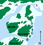
Close to the mainland at the eastern edge on the Navy Islands is Mulcaster Island. Mulcaster Island is tucked between Downie, Ninette, and Potato Islqnd with Lancaster the final in the group, closest to the shore. The trees on this island are the mainly pine, with oak, hemlock, and beech growing in the deeper pockets of soil. Historicaly was named name for a gunboat captain in the 1812 war. It is not possible to get close to Mulcaster from the north and west sides. Downie Island AnchorageThere is a quiet, if a little weedy, place to anchor between Ninette and Collier Islands north of Mulcaster, that is accessed from the main channel runing between the islands. 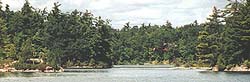
Anchoring is good in the bay (picture) to the north ( 4 ) between Lancaster Island, sheltered by Patato and Mulcaster itself. You can feel your way in to where you leave yourself adequate swing room, a litle off the channel and its wake. To use the dock located on the east side, north of the rocks or islets the crib dock ( 2 ) is found at the back of the bay on a small point. When you approach keep at least 120 feet away from the small rocks (or islets) on the south side, lining up on the dock from mid channel favouring the north side. 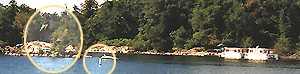
At the south west end of the island there is a large crib dock ( 1 ) with 4 to 6 feet on its outside and shallower on the inside, which parallels the shore. The area can be rough due to wake, so ensure that you deploy adquate fenders when tying up here. 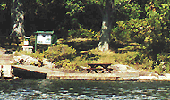
Facilities ashore are spartan having only toilets, a picnic tablem and a couple of camp sites as well as toilets. The island worth walking around and is easily accessable to the Glen House Resort located on the mainland. To reach Gordon Island you must ppick your way through the narrow channel between Horseback Point and Otty Island which can provide you an anchorage to the north of Hickey. Or proceed out into the open water south of Stave and pass through the Gananoque Narrows which is how we decided to go. |
Gordon Island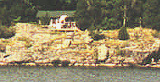
Gordon Island sits off by itself, west of the majority of the Navy group and has been used by man longer than any of the others. Most people who are cruising the islands first see it from the channel leading from Gananoque to the Gananoque Narrows. The soouth end of the island has steep cliffs with a smaller cottage on the eastern point. 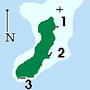
This is yet another of the St Lawrence Park islands and has a good display and trail with an octaganal period picnic shelter circa 1905, near the centre dock. You can pick out the green roofed white structure from a long way out. 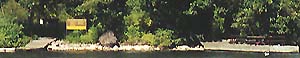
Gordon Islands main dock ( 1 ), made up of two sections, a floting tip and fixed crib with a limited draft of 3 to 4 feet is at the southeast corner of the island. 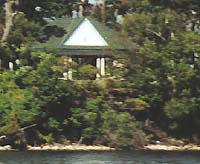
The larger of the docks ( 2 ) is along the the east side and is a T section having 5 to 7 feet of water along it. The third option is on the north side, however you must approach by following the west side giving yourself at least 120 feet off from the shoreline. There are two docks ( 3 ) with the west one having enough depth for sailboats while the other is suitable for smaller boats only. Stave & Hickley Islands AnchorageUsually you will set an easterly course due to the prevailing SW winds and islands effect on it, but even if the wind swings to the east it is still good so long as you have left enough swing room. There is adquate depth for fairly large boats and the area is perfect for exploring with your dinghy. 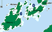
It is possible to approach from the south or the north depending on where you are on course from. Entering from the north your course leads between Hambly and Otty Islands where you need to maintain as close to centre as you can. Use considerible caution when approaching from the south as the small bush topped islet in the middle of the course to which you must stay to the west of, giving it 30 feet of clearance. We mentioned dinghy play but leave your motor on board as much of this area is home to herons bitterns and ducks. A visit to Mollys Gut running between Stave and Hickey is a wildlife treasure remembering that it is their home and definatly not an area for motors. |
WOLFE . BATEAU CH . ADMIRALITY . LAKE FLEET . GRENADIER . BROCK . EASTWARD |
Features & Reference |
Cruising guides |
|
|
Sponsored by Canadianet Communications for all your digital image acquisition requirements copyright 1999 2000, 2001 all rights reserved |