www.cruising.ca Lake Fleet SHUGAR & Gananoque Narrows Canadian Hydrographic Charts 1437, 1438 |
|
www.cruising.ca Lake Fleet SHUGAR & Gananoque Narrows Canadian Hydrographic Charts 1437, 1438 |
| GANANOQUE . ENDYMION . CAMELOT . SUGAR . GANANOQUE NARROWS |
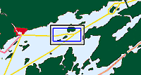
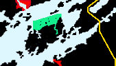
Sugar Island
The main Canadian channel leads close by Red Cap Island. Following our course through the islands eastwards down the middle channel you will pass Astounder Island with its prominent light before seeing Shugar Islands south shore. Sugar Island has a bay on its north shore where you can slip between it and Squaw Island or on the south west face between it and Astounder Island. 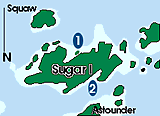
The anchorage areas of Shugar Island are both relatively exposed to channel wake with the south side allowing you to get the furthers away however the approach tricky. You are left the choice of approaching from the west between Psyche and the north shore of Shugar or Very Carefully picking your way in from between Axelman Island. In either case we found the anchorage out of our way, which may make it worth the effort or not. 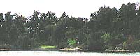
The more accessible anchorage the Shugar Island provides is reached on its north side. In my opinion it is a bit too close to the gananoque Narrows and main channel leading to and from Gananoque for a high rating. On the other hand it will be sheltered from the prevailing wind and easily accessible if you choose not top pay the Thousand Islands Parks Tribute of $ 20.00 for overnight stays. The bay itself is shallow with gentle grassy areas bordered with trees. Gananoque Narrows Prince Regent Island
If you are to travel east or west within the Canadian Thousand Islands you have only two choices.
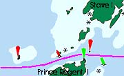
We will place this with the Lake Fleet & Navy groups although most courses lead you through this channel either to - or from Gananoque. If traveling east from Gananoque the deceptivly open water south of Gordon Island, to the north of the Lake Fleet Islands has some nasty surprises. Follow the channel markers as at 44 degrees 19.30 north and 76 degrees 7 minutes lies Jack Straw shoals, marked with a series of lit aids J4G and J5R. There are numeroous rocks on either side of the marks and the shoals extend both north and south for a considerible distance with many semi submerged or awash rocks.. Shortly to the east of the Jackstraw Shoals you sill see Scorpian Rocks to the south of your course. Leaving the Scorpians to your south the channel is well marked to the Gananoque Narrows passing Squaw Island to the south. As you approach from the north or east you are funneled in to a narrow passage between Stave Island on your north and Prince Regent to the south. The narrows is well marked but very busy with sightseeing boats on their way to and from the eastern islands. 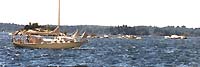
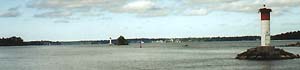
Approaching from the east. you will leave the canadian Middle channel at H23 and trun to the west. The Gananoque Narrows east entrance has a flashing green light on Prince Regent Island and a flashing red set to the north, both on the familiar circular towers. 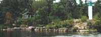
If you are given a choice it is best to time your passage through this few hundred yards so as NOT to coincide with a tour boat as it would appear that they do not heed the posted 10 kmh limit. It is this traffic which passes the Sugar Island anchorage on your south side. |
WOLFE . BATEAU CH . ADMIRALITY . LAKE FLEET . GRENADIER . BROCK . EASTWARD |
Features & Reference |
Cruising guides |
|
|
Sponsored by Canadianet Communications for all your digital image acquisition requirements copyright 1999 2000, 2001 all rights reserved |