Bateau Channel |
Bateau Channel |
|
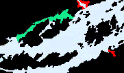
As we are cruising the Thousand Islands from Kingston there are two choices to the east Gananoque, The Admiralty Lake and Fleet Islands. The course is divided by Howe Island with the main shipping channel to the south and the more protected Bateau Channel to its north. Throughout history smaller vessels have chosen the Bateau Channel to avoid the exposed water which lies to the south of Howe Island. As you approach the entrance to the Bateau Channel Treasure Island (private) lies to your north and protects a sheltered basin known as Shelter Cove. Treasure Island itself is a dream location for a home and dream home you will find there but the docks are private and residences high end. Within this cove is Treasure Island Marina accessed by a privately buoyed channel with approximately 9 feet of depth but outside the channel. 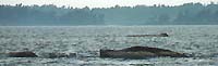
Entering the channel from the west follows a course that leads between the low lying Spectacles which surrounded by limited depth and Milton Island to the north. The Spectacles are distinguishable by their few barren trees stuck in the middle of their humps, however there are other parts to the shoal which are not so easily visible. It is important not to run too far east when rounding the Spectacles as Howe Islands Cassidys Point has shoals which run westward from its tip. It is important to pay attention to the channel markers when entering the Bateau Channel as the other shore northeast of Cassidys Point has the nasty Cassidys Shoal which is marked with a green channel marker. 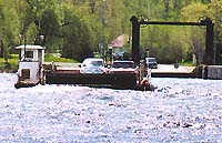
Once clear of these obstacles the channel is relatively clear of obstructions midchannel although the water close to shore becomes shallow. Proceeding east of the Cassidy Shoal marker 1.5 miles you will encounter a ferry crossing which operates with a cable system. As the tow line extends at an low angle from the ferry you must not cut close astern or risk hitting the tow line. The channel opens out a bit here and Grassy Point is visible on the north side of the channel. The waterway narrows a bit as you proceed east and watch out for the markers at the narrow point where there are several obstacles. 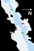
Minimum depths are approximately 10 feet when you approach the first mark and much deeper most places. As you approach from the west you will find green J23 of the southern side of the channel and a flashing red marker on the north side on a small spit. Continue leaving J22 red to port and J21 green to starboard and there is no problem. As you pass through the narrows you enter a 10 kmh zone which pretty much extends to the east past the Trident Yacht Club. Bateau channel looking west from Trident Yacht Club towards the narrows. 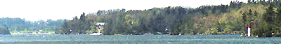
The passage east opens up again as you pass Byrne Point on Howe Island and Trident Point on the mainland where the Trident Yacht Club has its facilities. Working together the Trident Yacht Club Members were found getting their masts up for the season in the sheltered basin. However if you should try to drive to the club the road in is an obstacles course of huge potholes. There are a fair number of slips at the marina which are exposed to the channel and excess wake will be quickly noticed. As you cross Johnson Bay on the south shore remember it deceptively shallow and avoid entering it. As you approach the east shore of the bay which is Cooks Point stay south of Grog Island marked with a flashing red marker and red J10. This is the end of the speed zone as the bay opens out. Passing Firearms point to the north and Point on the island you are clear to the end of the eastward passage marked by green 17 where the channel turns southward. The channel gives the shallower water on the south shore a wide berth, but many power vessels with under 4 feet of draft make the short cut with care. To the north east near Willowbank there is a small bay formed where Brown Creek and Gander Creek enter the Bateau Channel. There is a airport not far back from the shore on the south side of this bay and a marina accessible by a privately buoyed channel at the head of Brown Creek. Reported depth of this channel was approximately 4 feet. 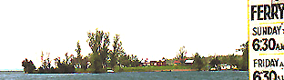
As you reach the eastern end of the channel the passage narrows between Gillespies Point and Bishops Point where you will encounter a second cable ferry requiring the same caution. The tow point mark the exit of the channel and once clear of Bishops Point you are in the Admiralty Islands. |
South of Howe Island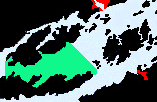
This is the deep Channel and except for the prior cautions when rounding the Spectacles and staying out from Wolfe Islands Holliday Point marked by green H37 which marks a shoal and exposed rocks there are no problems along this route |

|
WOLFE . BATEAU CH . ADMIRALITY . LAKE FLEET . GRENADIER . BROCK . EASTWARD |
Features & Reference |
Cruising guides |
|
|
Sponsored by Canadianet Communications for all your digital image acquisition requirements copyright 1999 2000, 2001 all rights reserved |