|
|
| Welcome to Cruising.ca. This site uses frames. Please click here to correctly view the site in context. |
|
|
| Telegraph | Narrows | 44degrees10minutes:N | 77degrees07minutes:W |
| Napanee | River | 44degrees12minutes:N | 77degrees01minutes:W |
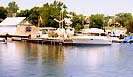
Deserontowas at one time a thriving timber exporting and ship building town, but over the past 40 years it has lost most of it's past glory and is now but a shadow of it's old self, never the less it is still worth while to take a rest and stretch ones legs,look around the town and restock the galley. Deseronto is on the north side of Mohawk Bay 17 miles east of Belleville. The most prominent features being the white water tower ( 217 feet of elevation ) which is easy to see from Long Reach and Post Office Clock and is lit but may be obscured when approaching from the south. The remains of the old town wharf is 0.25 mile NNE of Foresters Island. There are a number of out-falls and inlets, a sewer outfall is located a little less than 200 yards NE of the old wharf and a submerged inlet 15 feet below the surface of the water is just west of the remains. Deseronto Marina is 0.2 miles NE of the abandoned wharf. Deseronto Marina is a full service marina with an older 30 ton traveling lift, two launching ramps, power, telephone, picnic facilities, and a marine store, gas but (NO diesel) fuel are also available. For the Bay of Quinte the marina has a couple of dozen deep water slips available although vessels with over a 5 foot draft have had trouble launching during the 1990 low water periods. The covered slips on the west side of the marina are the most notable feature. Caution should be maintained as the entrance to the marina pier is between two cribs which are marked by buoys. Improvments for 2000 are currently nearing completion and will include a sailors lounge. This is a friendly and cost effective marina which provides a relazed atmosphere at reasonable rates. Deseronto Centennial Park west of the Marina, on the NW shore, is three tenths of a mile west of the old wharf. It has a concrete launch ramp, picnic facilities, playground, beach, potable water, washroooms and a snack bar. There is free overnight docking for two or three boats, but water depth is variously reported as only 2 or 4 feet of water. Foresters Island and Grassy Point as seen from the west To the north of Foresters Island is Mohawk Bay and the entrance to the Napanee River. This area offers excellent fishing and the Pickerel bite near the end of the summer in the waters off the marina in the entrance to the river. |
Mohawk Bay Park is a trailer park and campground with some shallow dockage further to the NE past deseronto Marina. For commercial and steel vessel people you will find a experienced steel shipbuilder located on the north shore just west of the day use park. There is a seaplane landing here and numerous daily flights, including touch and go practice landings come and go constantly so be aware of engine noise when in the area to the south of Foresters Island. A short walk north up to main street which has all the basics such as, a Foodland Grocery Store, Post Office, drug Store, Home Hardware, a branch of CIBC and there is laundromat close by on George Street. There are several restaurants in town including the United where one will find great pizza and a interesting rost beef melt that is smothered with motserrela cheese and hot peppers. The towns museum is above the library on Main Street has displays of both Town and Mohawk artifacts. As a historical note Deseronto was the landing place of many of the Empire Loyalists. These were people that remained loyal to the British Crown during the War of Independence ( often referred as the American revolution) among them was a Mohawk Chief by the name of Deserontyou, for whom the town was named. the present name of the town was assumed in 1880. 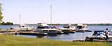
If you have shoal draft and wish to explore the Napanee River which flows for another 3 miles east to Napanee. This is a narrow channel with dense weeks on either side so caution is required. If you do have a shallow draft vessel such as a houseboat Napanee is a worthwhile stop on your Bay of Quinte cruise. The town itself is picturesque with all major banks represented along with other essential shore side services. The main street is two blocks north of the town marina which is free and always has transient space available next to the park. 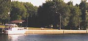
Unfortunatly there is no longer a marina in Napanee due to the low water levels however there is a gas station on the south side of the bridge which crosses the river to the east of the town docks. |
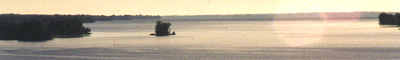
Telegraph Narrows looking westward toward Belleville
|
There is a bridge for HWY 49 with a 90 foot vertical clearance 0.8 miles south of Deseronto. The marked channel is boyed, one mile in length and 150 feet wide having a datum depth of 10 feet. You enter Telegraph Narrows from the east 0.8 miles to the west of the highway bridge. Telegraph Islnd is at the west end of the narrows, 200 feet south of the channel |
Telegraph Island light (459), mounted on a white tower with a green painted upper part at an elevation of 33 Ft.is located on a pier at the north side of the island Continuing west from Deseronto one enters the Telegraph Narrows 2 miles SW of the town. The channel is 150 feet wide, 1 mile long and well buoyed. |
|
Deseronto Marina Ltd. |
| Depth | Length | Transient Berth |
| 7 feet | 50 | 30 |
| Fuel | Pump Out | Shore Power |
| Gas | Yes | Yes |
| Water | Restrooms | Showers |
| Yes | Yes | Yes |
| Repairs | Sales | Marine parts |
| Yes | no | no |
| Storage | Trav Lift | Launch ramp |
| 100 | 30 Ton | Yes |
| Laundry | Rentals | Food Service |
| Yes | ||
| Recreation | Season Berths | Live Aboard |
| Yes | Yes | No |
| N. Lake Ontario Outer Route Bay Quinte Murray Canal Trenton Belleville Deseronto Hay Bay Picton Prinyners Cv |
 Not for navigation, always Hydro graphic Charts