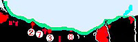
 50 Mile Point - Grimsby Harbour -Jordan Harbour |
| Way point: 1 mile N of Harbour Entrance | 43°14.62' :N 79°37.33' :W |
| Just off Entrance | 43°13.62' :N 79 °37.33' :W |
| Way point: 1 mile N of Harbour Entrance | 43°15.01' :N 79 °41.06' :W |
| 0.25 N of Entrance light | 43°14.25' :N 79°41.06' :W |
| Way point: 1 mile N of Harbour Entrance | 43°13.20' :N 79°33.07' :W |
| Way point close to Harbour Entrance | 43°12.20' :N 79°33.07' :W |
|
South of Hamilton the high Niagara Escarpment lies 3 miles inland closing to 1 mile inland the shore at Grimsby where the escarpment recedes to the west until Queenstown on the Niagara River. This area is known as the Niagara Fruit Belt with several wineries in the area. Proceeding SE from the Burlington Canal the shore is sand beaches for a distance of 5 miles. As one proceeds to the east this shoreline rises to a low bank with a narrow strip of rocks at the waters edge. As one approaches Fifty Mile Point the shore becomes a sand beach again. A scientific tower is located offshore from Van Wagners Beach 2.3 miles SSE of the Burlington Canal entrance . It may be identified by its square platform with four legs and is painted a bright yellow. Van Wagners Beach Light (537.8) is located on top of this structure and is privately maintained. There is a submerged power cable crossing to the scientific structure from shore in a SSW direction. There are also 3 submerged pipelines 2.7 miles SSW of the Burlington Canal entrance. A noticeable landmark is the blue sphere of the Hamilton Sewage Treatment Plant located 3 miles SSE of the Burlington Canal entrance. 3.4 miles SSE of the Burlington Canal overlooking the lake is a memorial to the crew of the Hamilton and Scourge schooners and the 53 lives lost in their sinking. To find out more one can visit the interperative center which is located nearby and which contains much more to the days of the sailing schooners and these sinking. 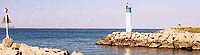
As you approach Fifty Point entrance there is a prominent land fill located to the south of the entrance, with a small arms range directly south of the point. The landfill extends for 700 feet into the lake and rises to a height of 40 feet. Fifty Point is a surprise delight on the west shore of Lake Ontario. The facility is operated by the Hamilton Region Conservation authority and has expansive camping and boating facilities along with an excellent clubhouse and restaurant. Fifty Point is 8.5 miles ESE of the Burlington Canal, it is low lying and wooded. Operated by the Hamilton Region Conservation Authority is part of a 1980 acre park. The boating facilities offer a man made harbour with marina with excellent facilities. 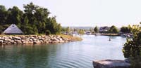
On approach the conspicuous feature is the 8 tall communications towers with air obstruction lights approximately 1 mile east of the harbour. A large spit of land 20 feet to the east extends almost 700 feet into the lake and is 40 feet high. Harbour Entrance is 0.2 miles east of the point and close west of the landfill spit. You enter the harbour between two rock breakwaters. The approach is marked by the Fifty Mile Point Sector Light (537.9) which is displayed from a 24 foot high white circular tower with green upper part located on the east breakwater. This light is visible from the western approaches from east through south from 203 °rees to 183.5 °rees. ware of the sector lights on approach. The west breakwater is marked with a red day beacon. Once inside the entrance the channel makes a sharp turn to starboard to enter a well protected harbour. 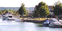
Fifty Mile Point Marina is operated Hamilton Region Conservation Authority and controls the entire basin. the well maintained marina can often be busy so reservations are recommended. From Fifty Mile point to Newport Harbor is a distance of 3 miles CAUTION - FIRING PRACTICE RANGE The Canadian forces maintains a small arms range 0.6 miles to the ESE of Fifty Mile Point which extends 1.5 miles offshore. The range parameters are marked by spar buoys and full details may be found in the annual Notices to Mariners. Their light are: Grimsby Small Arms Range Light buoy WY (538.2) and Grimsby Small Arms Range Light buoy WY (538.3) which mark the outer edges of the firing range. CAUTION - there are rows of ruined piles extending 164 feet offshore at the small arms range and are up to 7 feet high. 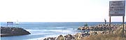
Newport Yacht Club Marina is found 5.8 miles SE of the Burlington Canal near Stony Creek and 3 miles west of Fifty Mile Point. Its entrance faces to the NW and is entered between two break walls. The break walls are rip rap and vary from 10 to 15 feet in height with the western break wall extending 394 feet offshore.This is a new harbor and town house facility and there are few facilities other than mooring. 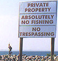
When visiting the most striking feature of this successful marina town house development was the exclusivness of the facility which makes little concession to those who do not own property or make arrangements. We can report that the natives are friendly in spite of the well posted facility. 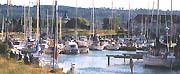
Newport Lights: a flashing Green Light is located on Neptune Spectre which adorns the outer end of the east break wall. There is between 10 and 12 feet of depth in the harbour. this is a large modern harbour and has 240 slips of which 20 to 30 are available or transient boats. CAUTION- ruins of a wharf constructed of steel and concrete are 0.1 miles offshore 1.8 miles SE of Fifty Mile Point. these ruins extended to a height of 5 feet in 1994. A group of radio towers is located near shore 1 mile SE of Fifty Mile Point and have air obstruction lights. Grimbsy Harbour is a sheltered basin 3.7 miles ESE of Fifty Mile Point. It may be entered between two stone break walls 7 feet high and 30 feet apart. Grimbsy Harbour is a customs reporting station for pleasure craft. 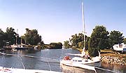
Grimsby Harbour Grimbsy Harbour Light (538) is located on the outer end of the east break wall with an elevation of 30 feet from a white circular tower with green upper portion. 1999 HARBOUR UPDATE due to the shared nature of the entrance channel a disagreement regarding the dredging has evolved between the marinas, consequently the entrance channel is silting up badly and even relative draft ( 5 foot) vessels have reported difficulty. The harbour is subject to silting and is no longer periodically dredged. There is a pier like structure located 0.1 miles to the west of Grimsby harbor which is a concrete walkway over a municipal pipeling there are NO FACILITIES or shelter here. CAUTION due to boulders and ruins of old wharfs at Grimsby Beach should be avoided by staying at least 0.2 miles offshore. 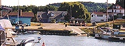
Foran's Marina is at the south end of harbour and has repairs and services. Lakecourt Marine is at the north end of the harbour via the first starboard side channel. Proceeding east from fifty mile point to Jordan Harbour is a distance of 11 miles with a shoreline of largely wooded bluffs. Three bluffs just east of Fifty Mile Point rise to a height of 10 feet, At Grimbsy Beach the height rises to 39 feet and then become much lower to the east. To the east of Jordan Harbor below the Beacon Harborside Inn are breakwaters protecting the marina basin. These breakwaters have an elevation of 10 to 13 feet. You enter the Beacon Marina from the north west corner which is marked by a starboard day beacon on the south entrance wall and the Jordan Harbor on the north break water. Beacon Harborside Marina offers an excellent retreat ashore offering an excellent restaurant and friendly bar. Rooms are reasonable and boast an inside swimming pool and sauna. The marina has reported depths of 10 feet and transient dockage and facilities with fuel, pump out and other facilities . Jordan Harbor Light (538.5) is privately maintained, located on the west end of the north breakwater at an elevation of 30 feet shown from a white circular tower 12 feet high and having a green upper portion. 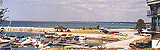
Jordan Harbour is located 8 miles west of Grimsby harbor, 5 miles west of Port Dalhousie, 11 miles from Fifty Mile Point. When coasting this shore CAUTION is advised as Shoal Water extends 0.3 miles offshore, one is advised to stay well offshore for this section to avoid the dangers. Jordan Harbor is on the Lake Ontario side of a nearly landlocked bay. On approach you can see a large grounded pirate ship on the north side of the harbour basin. The entrance to the bay is sheltered to the east by a small break wall area, then is under the two bridges of the Queen Elizabeth Way which only have 7 feet clearance. This tends to be a very shallow bay with depths in the entrance of 3 to 3 feet with 3 feet in the bay. There are NO facilities within this bay as of 1999.For larger vessels there is an artificial basin just east of the entrance on Lake Ontario which provides a sheltered basin. The entrance is from thew NW corner of the breakwaters and have a (IsoG) green light shown from the end of the north breakwater from a 12 foot high white circular tower with green upper portion. Beacon Harbourside Marina maintains a marina in the basin with 11 feet of water and facilities. Beacon Harbourside Marina (905) 562 7888 is perhaps better known for its food which range from a coffee shop family restaurant to licensed lounge. The Inn itself has relaxing facilities and include a indoor pool and sauna available to visiting boats. Anchorage is available in the basis which has a sandy bottom. |
|
Newport Yacht Club Marina
|
Fifty Point Marina
|
|
Foran's Marina
|
Lakecourt Marine
|
|
Beacon Harbourside Marina
|
| Niagara on The Lake I Port Weller I Port Dalhousie I 50 Mile Point I Hamilton I |