
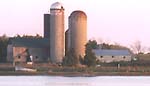
Amherst Island
Canadian Hydrographic Charts 2017,2064, 14802,1439
Amherst Island, Big Sandy Bay & Waupoos Bay
| Cruising.ca Ad Rates Bay Quinte Outer Route Isl Murray Canal Trenton Belleville Deseronto Hay Bay to Picton Adolphus Reach |
|
Welcome to Cruising.ca. This site uses frames. Please click here to correctly view the site in context. Page updated Oct 1,99 with full sized images gallery available for thumbnail images |
|
Amherst Island
Canadian Hydrographic Charts 2017,2064, 14802,1439 Amherst Island, Big Sandy Bay & Waupoos Bay |
|
|
| Amherst Isl | Amherst Bar | 44degrees11minutes:N | 76degrees37minutes:W |
| Amherst Isl: | Buoy KM4 (FaR), | 44degrees06.56minutes N: | 76degrees48.38minutes W. |
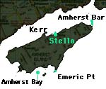 Departing Kingston on a westward passage one passes between Amherstview and Amherst Island. AS you pass the entrance to Collins Bay you approach the Amherst Bar which extends from the east tip of the island trowards the mainland. Amherst Island is a large Island 5 miles west of Wolfe Island. The North channel separates the mainland from the mixed cultivated and wooded island. Amherst Island extends from Amherst Bar to Emeric Point but there are no prominent features along the shore. E and SE shores extends from Amherst Bar to Emeric Point. |
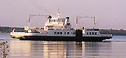 The Island is rural, with farms, a few cottages, and a population of 400, who reach the mainland via a provincial operated ferry between the public wharf at Stella and Millhaven. The entire island is quite remote with topography similar to many of the mid lake islands. Cruising sailors will find a few anchorages along the protected north coast near stella however the majority of the shoreline is rock shingle with shallow water extending outwards some diustance. This water has numerous shoals which require local knowledge so stay to buoyed channels. On the west end the Upper Gap connects to the North Channel. Buoyage is good, so follow it as there is a shoal around the northeast end of Amherst Island. Also eastward towards Kingston and south to the open lake require staying in buoyed channels. The south shore is defined by two flashing red lights, one south of Grape Island and one west of Emeric Point. |
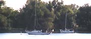
Stella Bay Stella Bay has an average depth 20 feet This is a quiet place and one will be welcome if one asks permission before going ashore, and not departing too late. A Ferry Dock on Stella Point separates Stella Bay from Wrights Bay. 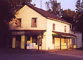
Glen's General Store in Stella has basic supplies and is open 7 days a week in season or you might wish to try the Back Kitchen, recommended by the local resident, in Stella if you want to eat out. 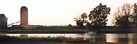
|
On the south west shore your options are limited and the overall landscape quite deserted.Long Point Bay is entered between Emeric Point and Nut Island. In all but S or SW winds it is a good anchorage offering a sand or mud bottom for holding. From Emeric Point passing inside Nut Island to Wemps Point there is a deeper anchorage in Amherst Bay with limited protection from Nut Island.Depths vary from 8 to 19 feet. However this location is exposed to southerly weather and the shoreline offers almost no habitation and a shingle beach. There is a Public wharf on Long Point Bays east side with a 151 foot long log structure. The bay depth decreases from 12' for roughly the first 60' to a minimum of 4' . We recommend that you anchor mid bay, as rocks line the shore and mud and sand form the bottom.Long Point Bay is between Nut Island and Emeric Point on the south shore of Amherst Island. The eastern side of the bay has a dock used by Emeric Point fishermen. Although you may be allowed to tie up here, it will be on the understanding that you may have to move whenever fish are being unloaded . |
| Cruising.ca Ad Rates Bay Quinte Outer Route Isl Murray Canal Trenton Belleville Deseronto Hay Bay to Picton Adolphus Reach |