|
www.cruising.ca Prince Edward Bay & Long Point Canadian Hydrographic Charts 1439, 22064, 14802 |
|
www.cruising.ca Prince Edward Bay & Long Point Canadian Hydrographic Charts 1439, 22064, 14802 |
Prince Edward BayPlease note this will become a seperate page in the next editionPrince Edward Bay is to the east of Prince Edward County and provides some of the more interesting cruising to be found in eastern Ontario. Prince Edward County itself is a long established loyalist stronghold with considerible european influence. There endless activities ashore and you might check out the county's websire for shore side activities. There are several anchorages providing protection from the prevailing winds here. However CAUTION should be exercised since South Bay is notorious for becoming extremely difficult should the wind swing to the NE. The most popular anchorages lie close to Waupoos Island or close to the east in Smitty Bay . You will find these covered within the Waupoos Island page here. 
We will continue this cruising section starting from Van Dousens Point which is the south west corner of P.E.C. and lies to the SW of Waupoos Island proper. If you apprach from the passage to Kingston you will leave Waupoos Island to your west and see the shadow of the Long Point spit of P.E.C. to your south. If you arrive from the passage between Waupoos Island aand Mainland or Smitty Bay there is little to mark your crossing into the deeper water of greater Prince Edward Bay except that the depth will drop to 40 feet. The shoreline on the county to the west is wooded with a few small cottages along the shore. Rounding Van Dousen Point the fishermen have a pleasent surprise as the bay from here to Black Creek is well populated with Bass, Pike, Perch and in the deep water there are lake trou and salmon at depths varying from 35 to 50 feet. We have found many 10 inch perch here and big close to 3 foot pike also lerk in the shallowerwaters among the weeds. The water here is relativly deep holding in the teens all the way to the entrance to Black Creek where the land begins to rise from the low lying rocky beach to hills on either side of Black Creek which are perhaps a hunbdred feet high. As tempting as it might look be carefull of the shallow area in the middle of the mouth of the entrance to the creek. 
The south shore retains its wooded cloaked heights for some distance to the SW as the bay begins to shoal to Port Milford where there is an active Mariners Museum. The bay here is shallow and the surrounding land is green and low lying, making one wonder just what the lighthouse at the Mariners Park guides. The park itself is a worthwhile visit although I can not see how you would get there by any size of curising vessel unless by a long dinghy trip. 
Most of this part of South Bay is far too shallow to allow anything but outboard powered craft. There are small boat facilities on the south shore on Flatt Point and if you follow the deep water which lies west of Flatt Point. 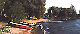
For those seeking an out of the way spot for a rest, shore based vacationers can enjoy ( 2 ) Smugglers Cover Campground which is quiet well maintained on Flatt Point, with a sandy beach and small fishing boats. Even in August we found the campground had plenty of available spaces providing a view of the water. The facility itself would be great for a family as there is little traffic, a good playground, and a small but adequate store on the property. 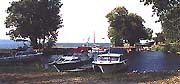
On the point itself is ( 3 ) Johstons Marina, (613) 476 3972, which provides a total of perhaps 6 to 8 slips suitable for outdrive type mid twenty foot vessels behind a secure breakwall. The marina itself should be secure in anything but the most violent of storms but too small for most sail boats. For larger vessels there is a pleasent anchorage once you tuck in behind the point itself and the Smugglers Cove Campground with 15 feet of water. 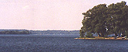
For the cruiser the area to the east of Flatt Point ( 1 ) offers an excellent day stop in Half Moon Bay which is bourdered on the land by the Little Bluff Conservation area. When approaching from the north the bluffs are visable from as far away as Waupoos Island. In the afternoon you will pick up the glint of a silver metal roof to the western edge of the bluffs proper. 
Little Bluffs stand over a hundred feet above Prince Edward Bay sheltering Half Moon Bay itself. A public rocky beach ( 3 ) extends from the foot of the bluffs in a crescent shape for almost a kilomenter to the east, offering excellent swimming or a shore side picnic. Anchoring is weedy but a 35 lb. plough or fisherman will hold well amounst the weedy botton. There is little to distinguish the shoreline from the bluffs to Point Traverse. The shoreline is scrub pine and cottages above a low lying gravely beach with no protection. As you approach the eastern end of the point the cottages disappear where the bird sanctuary starts and the shoreline rises to low bluffs above the same gravely beach with scrubby pines inland. Point Traverse itself has perhaps fifty foot high bluffs overlooking the waters between Point TRaverese and Timber Island. Point Traverse, Long Point & Long Point Harbour
IMPORTANT Any soundings shown on any graphics on this page are in fathomsUSE A CURRENT OFFICIAL HYDROGRAPHIC CHART
One thing that Long Point has plenty of is hazards. Whatever you do, do not attempt to enter or round close off the point unless you have a chart, good navigation or knowledge of the area like the back of your hand! If approaching from the east between False Duck Island and Timber Island ( 3 ) you must pass close to ( 4 ) Gull rock, which is almost directly east of the harbour entrance. Give yourself plenty of room and round well east of the point. If you approach from the south or south west watch your chart as Traverse Shoal ( 5 ) lies slightly east and south of the harbour and Long Point. The entire shore from Long Point to Rocky Point on the south side is strewn with rocky shoals. 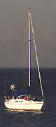
In prevailing winds and keeping an eye to the weather you can anchor just off Point Traverse on a rocky bottom. For those of you with wind generators you will find no shortage of wind here as it seems to be always blowing. There has ben a lot of mis-information printed regarding this landfall. There should be no doubt that the harbour itself is an interesting place to visit, marking an outpost from Ontario's past, as this harbour is for commercial fishing vessels. For the visiting boater don't believe what many guides have published. Thre are no facilities and there is NO DOCKING for visiting vessels. 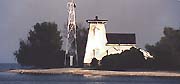
Approaching from the east the entrance to the harbour can bee seen from some distance out, well before sighting the markers. The entrance is from the east via a bay much like Main Duck. There is a white lighthouse to the south of the entrance where there is a cottage on the north shore past the eastern point of the bay. On the other hand it is an interesting anchorage for those with a moderate draft of five feet or less, and there are many similarities to Main Duck Island and Schoolhouse Bay. However this fishing harbor is still active. You must take care to avoid Traverse Shoal and Gull Island which extends east from Prince Edward Point toward False Duck Island. 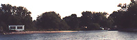
There is a red buoy ( R KL 4 ) several hundred feet from the NE point while the green marker ( G KL 3 ) is some distance out, almost off the light structure. The narrow entrance may be difficult to distinguish until you are within arms legth of the outer bay itself. 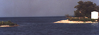
With the exception of a small white wooden shed on the south shore there is little to seperate the gravely beach from the narrow entrance to the harbor proper. 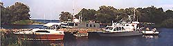
The charts show a dead straight entrance but we found it to lie just south of due west, at a slight angle. Once inside you will see the government dock directly in front of you. It is a wooden structure rising perhaps 5 feet above lake level and approximatly 20 feet wide. Between the Department of Fisheries and local residents do not expect to find any space to tie up here. 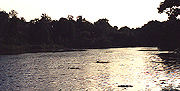
Watching you depth sounder you can find good protection just past the government dock if your hook is adequat,e as the bay is very well sheltered and should be considered a harbour of refuge for any unlucky enough to become trapped out here by a sudden storm. The bay here becomes quite shallow and has enough weeds to defeat most Danforth anshors. 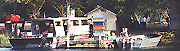
There is no mooring on the south shore of Long Point Harbour as this is used by local fishermen and are private and visiting cruisers are not overly welcome. This is not a tourist destination but remains a working fishing harbour. There are no facilities here other than an outhouse north of the government dock. |