It is close to impossible to demonstrate without internet access what separates cruising.ca.

The Internet is information and content although only 50% normal size each column would be a full width normal screen to the visitor.

This www.cruising.ca Ports of Call Cruising Guide sample is why the viewer stays in the site, original cruising.ca content

Long Reach Map

Not for navigation, always Hydrographic Charts

www.cruising.ca
Picton Bay,Long Reach, Hay Bay

Canadian Hydrographic Charts 2011, 2069

N. Lake Ontario Outer Route Bay Quinte Murray Canal Trenton Belleville Deseronto Hay Bay Picton Prinyners Cv

Picton Bay canadian cruising magazine for boating cruising and sailing enthusiasts online

The west end of Adolphus Reach leads into where the Bay of Quinte begins, forming a wide triangular bay to the west of Glen Island. Picton Bay and Long Reach form the longest north to south section of the Bay of Quinte extending from Picton at the south end, to Deseronto and the Napanee River at the North. For the purpose of this section assuming that we are proceeding east to west, entering from Adolphus Reach, we will explore Picton Bay and Picton harbour to south first. Then proceed northward up Long Reach.

canadian cruising magazine for boating cruising and sailing enthusiasts online

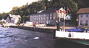
Glenora lies on the south east shore of the junction of these bodies of water. The ferry runs every fifteen minutes crossing Aldolphos reach. To the east of the Glenora Ferry terminal is the Fisheries offices and research vessel berths.

Picton Yacht Club canadian cruising magazine for boating cruising and sailing enthusiasts online

Passing between Glenora and Young's Point to the west, in most weather you can clearly see the very conspicuous Esroc Canada plant set atop the high cliff.

canadian cruising magazine for boating cruising and sailing enthusiasts online

This complex includes a conglomeration of buildings, covered conveyors paths, a 345 Ft tower and quarry stretching above its considerable lakeside terminal with its 12 dolphins joined by a catwalk. This loading berth is lighted at night, and very busy with up to 100 ships per year using the facility.

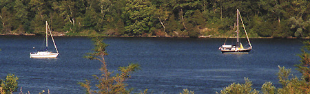
Picton Bay with it's steep, well wooded shore line is the southern end of the Bay of Quinte and 2 miles west of Young's Point. Conger shoal has a depth of approximately 16 feet and lies along the western part of Picton Bay .

Picton Yacht Club canadian cruising magazine for boating cruising and sailing enthusiasts online
Ram Island Anchorage canadian cruising magazine for boating cruising and sailing enthusiasts online

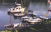
A favorite anchorage for visiting boats is behind Rams Island. However one must be careful not to try to pass to the north of the island when approaching the anchorage due to submerged rocks. Once you are tucked away to the east of Rams Island there is a well protected spot with little along the shoreline to announce civilization except a few farm houses at the top of the hill on the north shore.

canadian cruising magazine for boating cruising and sailing enthusiasts online

Continuing north you enter Long Reach,and soon ,off to starboard one can see Thompson Point at the entrance to Hay Bay. At the westerly end of Picton Bay lies the Town of Picton in Prince Edward county.

Hay  Bay

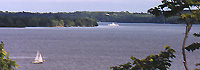
Hay Bay is a large bay with an extensive shoreline it extends 9 miles NE from the southern end of Long Reach and is entered between Shermans Point and Thompson Point.

Hay Bay is noted as an anchorage for small craft, however the depth of the water varies greatly throughout the whole of the bay so continuous soundings should be taken when within the confines of the bay. There are many areas of thick weed growth in shallow areas particularly in the north east quadrant.

canadian cruising magazine for boating cruising and sailing enthusiasts online

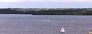
This Hay Bay photograph was taken from Shermans point looking to the SW.

Hay Bay is a fisherman's paradise, where one may aspect to catch pickerel, Large and small mouth bass, northern pike and if one is lucky a muskie. The shoreline has numerous smaller summer cottage areas set within the farm landscape. For the small craft visitor one may venture, with care, up one of the many rivers running into the bay and be rewarded by eating barbecued salmon for supper. At this writing (September 1,99) the pickeral have begun to bite in the shallower waters.

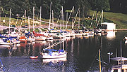
There are any resorts in Hay Bay offering some services to boaters visiting the area among which are:

Pickerel Park on the south shore at Hay Bay 3 miles ENE of Ram Island with water depths of 4 to 6 feet. Dockage, pump out, concrete ramp, some boat hardware, picnic area camping and pay phone, potable water, showers, laundromat, groceries, snack bar, ice gasoline, naphtha, playground and sandy beach bait and tackle.

This side would be a continuation of the left hand page on line as a full width screen


As you enter the south end of Picton Bay you will find a anchorage on the west shore as the bay widens slightly just before you reach the Prince Edward Yacht Club located at the foot of a steep hill. The Yacht club is often frequented by beautiful cruising vessels from recripricating clubs as this Choy Lee 32.

Further in the harbour you will find two more marinas on the east shore. The Picton Harbour Marian is operated by the town and offers a shore side stopping point and launching ramp. You will find a snack bar tackle shop and even a miniature golf course on at the SE tip if the bay at the Tip of the Bay Hotel and Marina close to downtown Picton.

canadian cruising magazine for boating cruising and sailing enthusiasts online


We now return you to the west end of Adolphus Reach where the Bay of Quinte begins and we will now proceed northward towards Hay Bay, Deseronto, and Belleville.

To the north of Youngs Point to the west of Glen Island is Malory Bay on the east side and Picton Bay to the south. On many fair nights you can find a reasonable anchorage along the north east side of Malory Bay providing you have fairly heavy ground tackle and do not wish to spend the time to proceed into Hay Bay or Picton Harbour.

Malroy Bay canadian cruising magazine for boating cruising and sailing enthusiasts online

All marinas who update their information already receive FREE listings roughly as shown here. What experience proves, is many visitors wish to know more about that particular marine service.

A click of the banner takes the visitor to your
full marina page.

Moreover for 2000 we have an incentive plan which will prove to you that the customer comes from our website which provides discounts to both the boater and the marina.

Blakewood Lodge Dockage, ramp, picnic area, dining, pay phone, drinking water, ice, and some groceries ; monitors VHF 68.

Hogsbck is a dangerous shoal which extends out from the eastern shore of Long Reach 1.8 miles north of Sherman Point the outer end of which is marked by a buoy.

Grassy Point and Green Point mark the NW entrance to Mohawk Bay, and the Napanee River. Grassy Point is more sparsely wooded and lower lying than it's neighbor In order to avoid the numerous under water obstruction, caused by the abandonment of log boom, sometime in the past, small craft should keep to the east of a line joining the two points of the cove.

North of Green Point the Bay of Quinte ends, widening out intoMohawk Bay, which is relatively shallow.

Foresters Island

Extending from Grassy Island is a sandy spit,which almost joins the low lying, wooded Foresters Island. This spit at times is over grown with rushes, but with local knowledge, one can steer a course between the island and Grassy Point.

There also shoals in this area,Catalaque 0.6 miles south of Green Point is the outer part of shoal water and extends to Buoy Q11 (449) and Carman 0.5 mile SSE of Green Point.

There are submerged cables 0.3 mile south of Green Point which continue on along the south shore as overhead lines and make for a useful landmark.

www.cruising.ca already provides basic marina information free to visitors

Prince Edward Yacht Club, Picton Bay,
R.R. #2 Picton Bay,Long Reach, Hay Bay
Phone: 613-,

Depth Length Transient
     
Fuel Pump Out Shore Power
Gas Diesel Yes no Yes No
Water Restrooms Showers
Yes No   Yes No   Yes No  
Repairs Sales Marine parts
Boat & Motors Boat & Motors Boat & Motors
Storage Trav Lift Launch ramp
10 Ton Yes No  
Laundry Rentals Food Service
Yes No   Yes No   Yes No  
Recreation Season Berths Live Aboard
Yes No   Yes No   Yes No  


This is a typical standard banner placement within the Cruising Guide.

Bancroft Top and Upholstery


Each of the above small (thumbnail) photos has a full sized image which viewers can view by clicking the image as shown below 50% size.
This will pretty much fill most computer screens.


Ram Island