|
Welcome to Toronto, the city of the next century.
After having lived there for 10 years I consider this to be one of the worlds greatest cities.

Facilities and harbours are so numerous that this is a developing site, it will never be complete. Internet resources of this city are so numerous that you can spend weeks simply investigating all that there is to do and see.
We shall,therefore, at this time present you an abbreviated synopsis of the places to berth together with a set of links to some useful websites about the city itself. After we have visited all the Toronto harbours we will add our comments on their suitability for visiting vessels , that is to say for non resident, non yacht club member seeking a good harbour with easy access.
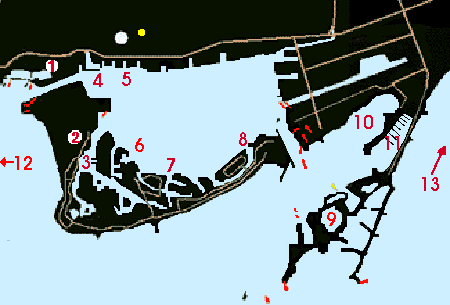
Toronto Harbour has many aids to navigation, rules, and channels, so because of this we will proceed only with the tourist part of this web site for the visitor . Suffice it to say that NO ONE should even consider visiting the Port of Toronto without a complete set of charts and current light listings. The city backdrop makes observation of navigational aids difficult which together with the constant traffic makes any hesitation dangerous.
Toronto Harbour Regulations
You are required to possess a harbour license to operate in Toronto Harbour. We recommend that anyone operating here for more than a quick visit check out the Port Authorities web site for complete details. Harbour Port Authority Web site
I quote directly here from the Port Authorities rules.
( A ) The Toronto Port Authority ("PTA") is responsible for the administration of By-laws respecting navigation in the Port and Harbour of Toronto for both commercial and pleasure vessels, including rules regulating the speed limits of vessels, licensing of power-equipped craft and safety equipment required to operate a boat. The By-laws within the limits of the Port and Harbour
of Toronto are enforced by the Toronto Police Marine Unit.
( B )
All recreational and commercial boat operators who have engine-powered vessels, whether the engine is the main power or only auxiliary, must possess an operators license from the Port Authority to navigate in the waters of the port and harbour of Toronto, which license can be renewed annually.
( C ) The limits of the Port and Harbour are defined as the section of the waterfront bounded by Humber River in the west, to Victoria Park Avenue in the east and stretching out into the lake along aline which runs south from the shore encompassing the islands and reaching a most southerly point of 1 mile from Gibraltar
Point.
|