 Burlington |
|
Burlington Waypoint:
|
For Burlington Canal Information here
|
Bronte to the Burlington Canal is a distance of 7 miles with a shoreline that is low with trees back of the beach. the section of coastline is without landmarks although you will observe the niagara escarpment 5 miles to the west is often visible to offshore vessels. 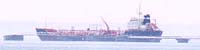
To the to the SSW West of Bronte 1.2 miles is the Petro Canada Oakville Refinery The refinery pier is 2,250 feet long with an 18 foot elevation. A berth for tankers is found at the outer end of the pier. Facilities are for commercial vessels with provision for water ballast discharge and delivery of water. Petro Shell Canada Oakville Refinery Wharf Light (531) is located on the outer end of the wharf and shown from a structure having a elevation of 18 feet. Conspicuous features of the Shell Petro canada Refinery are, two chimneys on the refinery site with an elevation of 505 feet each, with a black band at the top. Another Conspicuous reference is Mount Nemo (43°25' :N, 79°53' :W ( or chart 2077) which is located 8 miles ot the WNW of Bronte with an elevation of 680 feet above Lake Ontario with very steep sides towards the summit. the top is a plateau level for 3 miles to the north and south. Also Conspicuous is Rattlesnake Point (43° 28' :N, 79° 55' :W) which lies 6 miles to the NNW of Mount Nemo and is another steep hill. Submerged water intakes are located SW of Bronte harbour 4.2 miles. these intakes extend 0.4 miles offshore with the outer ends marked by privately maintained buoys. Burlington Harbour Fishermans Pier is a sheltered basin south of the Burlington Canal and has a ramp and some facilities. Burlington Sailing and Boating Club ( 2 ) is found at the LaSalle Park Marina with adequate transient space for visitors of reciprocating clubs. Rates are what other clubs charge and confirm with the officer of the day for information and slip assignment. 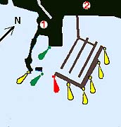
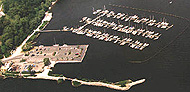
LaSalle Park pier and is operated by the LaSalle Park Marina Association the marina which is completely funded by the boat owners by very creative payment program from slip ownership as well as seasonal rental slips and a full-time marina manager The municipal LaSalle Park Marina ( 1 ) has 219 slips ands transient availability depends on the current status of seasonal slips. If you arrive after business hours tie up to the main dock outside the break wall until being assigned a slip. There is no overnight anchorage available here.
photo courtesy of LaSalle Park
The LaSalle Park Marina Association has a unique and very close relationship with the Burlington Sailing and Boating Club which also operates out of LaSalle Park. BS&BC offers to its members a complete racing program, clubhouse, pump out, mast crane, cruising program and limited winter storage. As LaSalle Park decided against charcoal BBQ's in the marina they found a interesting way to accommodate those wishing to BBS's, with a floating picnic area complete with tables and gas barbecues is available along the main walkway from the shore-line. You can reach them at (905) 633-9483 or toll free 1-866-203-4813. |
|
The southwest end of lake Ontario is marked by a narrow strip of land sheltering the waters of Burlington Bay. The strip of land now know ands the Beach Strip, once known as the Burlington Bar, is occupied by the communities of Burlington Beach and Huntington Beach. To enter Burlington Bay and gain access to both Burlington and Hamilton Harbours one must pass through the Burlington Canal which access through the Burlington Strip to Burlington Bay. The canal is entered between two concrete break walls of 0.2 miles in length and have a width apart of 240 feet. the channel depth and is 29 feet. Burlington Canal entrance Light Buoy H 9 is located 0.9 miles offshore to the NE of the piers. This is the reference point to aim for when making any offshore passage terminating with Burlington Bay. Canal Regulations are quoted in Sailing Directions Booklet CEN 300. 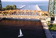
There are two high level bridges and a lift bridge crossing the canal. The Burlington Bay Skyway Bridge found 445 feet SW of the lift bridge has a clearance of 125 feet. The Lift Bridge has a clearance mid channel of 10 feet closed and 131 feet open. there is a overhead power line located 83 feet NE of the lift bridge with a clearance of 151 feet. 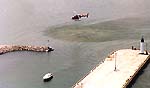
Burlington Bay Lift Bridge is in operation 24 hours a day, opening on the hour and the half hour for pleasure craft, or request for commercial traffic. Department of Public works maintains a radio facility on the bridge for traffic control purposes. Full details are found in the Radio Aids to Marine Navigation for the Great Lakes and Atlantic. 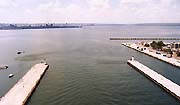
A submerged pipeline crosses the outer end of the entrance to the Burlington Canal, and is marked by privately maintained buoys. Burlington Canal South Pier Traffic Light (535) are located on the east end of the south pier, from a square white tower. There are traffic regulating light on the outer ends of the south pier near the outer entrance to the channel. Burlington Canal North Pier Traffic Light (533) is located on the east end of the north pier from a circular white tower with red upper portion and height of 20 feet. the light elevation is 27 feet Burlington Canal North Pier Inner Light (534) is found on the SW end of the pier in a white circular tower with red upper portion and an elevation of 27 feet. Burlington Canal South Pier Inner Light (537) is found on the west end of the pier in a 20 foot high white circular tower with green upper portion and an elevation of 27 feet. This light is visible from all sectors of Hamilton Harbour. Hamilton Harbour East Breakwater Light (537.1) is located the west end of the breakwater to the SE of the Burlington Canal South Pier Inner Light. the light is privately maintained and has an elevation of |
|
LaSalle Park Marina
|
Burlington Sailing and Boating Club
|
| Port Weller I Port Dalhousie I Jordan Harbor I 50 Mile Point I Hamilton I Bronte I |