|
Go to Hamilton to Niagara-On-The-Lake 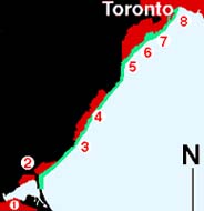
Humber Bay to Hamilton2077, 2085 |
| 8 Humber Bay | Off Bay | 43°36.20':N | 79°26.65':W |
| 7 Mimico | .25 S | 43°50.92':N | 79°30.58':W |
| 6 Lakeview | off brkwall | 43°33.72':N | 77°33.37':W |
| 5 Port Credit | off entrance | 43°32.80':N | 79°55.65':W |
| 4 Oakville | off brkwll | 43°26.31':N | 79°39.92':W |
| 3 Bronte | off brkwll | 43°23.55':N | 79°42.32':W |
| 2 Burlington | Bouy H | 43°18.58':N | 79°46.48':W |
| 1 Hamilton | Buoy H | 43°18.58':N | 79°46.48':W |
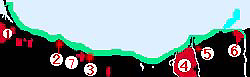
Hamilton to
|
| PORT | WAYPOINT | LATATUDE | LONGITUDE |
| 1 Hamilton | Buoy H | 43°18.58':N | 79°46.48':W |
| 2 50 Point | off ent | 43°16.32':N | 79°37.33':W |
| 7 Newport | 0.25 N | 43°14.25':N | 79°41.06':W |
| 3 Grimsby | off entrance | 43°12.20':N | 79°33.07':W |
| 8 Jordan Harbor | off entrance | 43°12.20':N | 79°33.07':W |
| 4 Pt. Dalhousie | brk wall ent | 43°12.72':N | 79°15.85':W |
| 5 Port Weller | Canal entrance | 43°14.75':N | 79°13.00':W |
| 6 Niagara | river mouth | 43°15.76':N | 79°04.07':W |