| Port Weller I Port Dalhousie I Jordan Harbor I 50 Mile Point I Hamilton I Bronte I |

Port Weller |
| Canal entrance 43°14.75' :N , 79°13.00' :W |
|
Proceeding eastward from Port Dalhousie to Port Weller the coastline is mostly clay bluffs of 39 feet height. The most conspicuous feature is without a doubt the huge parallel breakwaters of the Welland Canal which extend 1.2 miles offshore and are located 2.5 miles to the NE of Port Dalhousie. CAUTION WRECKS are located 0.4 miles east of Port Dalhousie 0.1 mile offshore. One of the wrecks projects above the water approximately 6 feet, and the outer wreck is marked by a buoy.
Port Weller Lights
The St Catharines Marina is located on the east side of the east break wall with reported depths of 6 to 10 feet with accommodation for up to 60 transient boats. 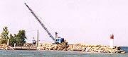
There is a land reclamation project to the east of the break wall. This is marked by the St Catharines Outer Light (544.) which is located on the east end of this project from a 26 foot high white circular tower of with red upper portion. 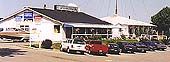
The Welland Canal has its east end here and I always find it interesting to check out the commercial yards and watch the activity. Port Weller Dry Dock is directly above lock one and always has some form of commercial shipping in for repairs or upgrading. 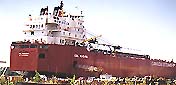
The back lot of Port Weller Dry docks is full of discarded portions of freighters and materials which provide a glimpse of how the big boats are constructed. 
Port Weller Harbor has a channel dredged to a depth of 27 feet 400 feet wide between two substantial break walls of earth and reinforced concrete. CAUTION ANCHORAGE IS PROHIBITED in the harbor approaches. A submerged power cable crosses the entrance of the harbor. MOST IMPORTANT CAUTION - this is a major international through fare for commercial traffic. Due to size and draft these vessels have the right of way and require a clear channel, emergency manoevers are difficult and the small craft operator are cautioned not to use the harbor un-necessary. 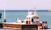
Canadian Coast Guard maintains a Search and Rescue lifeboat at Port Weller April to December. Tugs are available form Port Weller Dry Docks if required. Port Weller Harbor is 23 miles SSE of Toronto harbor, 7 miles to the west of the Niagara river. Port Weller Harbor is the Lake Ontario entrance to the Welland Canal and is an artificial harbor. The harbor is shared by two communities Port Weller East and Weller Park which are both part of the city of St Catharines. 
Recommended for large viewing Port Weller Harbor is entered between two concrete piers 597 feet long including the pier heads, with the center line of the entrance bearing due south. From the entrance the harbour center line extends for a distance of 1.2 miles to where the deflects 15 " east to align with lock 1 of the Welland Canal 0.4 miles to the south. wharf 1 is located on the east side of the harbor at the head and is 634 feet long. wharf 2 is on the head of the SW side of the harbor and is 1,289 feet long. A small craft tie up wharf for vessels weighting passage may be found on the east side of Port Weller harbor at mile 1.4. this dock is only for use of vessels transiting the Welland Canal. There is a direct line telephone located at the dock for contacting the Welland Lock control. |
|
St Catharines Marina
|
| Port Weller I Port Dalhousie I Jordan Harbor I 50 Mile Point I Hamilton I Bronte I |