| Port Weller I Jordan Harbor I 50 Mile Point I Hamilton I I Burlington I Oakville I |

Bronte |
Bronte Waypoint:
1 mile SE of entrance: 43° 22.82' :N , 79°41.33' :W
Just off the breakwater: 43° 25.55' :N , 79°49.32' :W
|
West from Oakville to Bronte is a distance of 3.4 miles. the shoreline is mostly wooded clay banks up to 40 feet in height. Behind the banks the shore looks densely wooded . Two submerged water intakes are located 0.2 miles SW of Oakville Harbour entrance and extend 0.4 miles offshore in a SE and SSE direction. Two submerged pipelines 2.0 miles SW of Oakville Harbour entrance the longer of which extends 0.4 miles offshore extend 0.4 miles offshore with the outer end marked by privately maintained buoys. 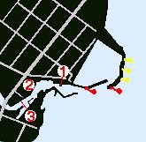
Bronte is a customs reporting station for pleasure craft. CAUTION anchored dead head of 8 inches in diameter which extends 3 feet above chart datum is reported 0.2 miles to the south of the above described pipeline. This dead head may be submerged and is a dangerous obstruction to be aware of. Bronte is a community which is part of Oakville and is located 3.4 miles SW of Oakville, 19 miles SW of Toronto. Bronte has scheduled transportation services and is located on Highway 2 close to the Queen Elizabeth Way highway. Conspicuous features which identify Bronte are a group of tall buildings NE of Bronte Harbour. Bronte Harbour is at the sheltered mouth of Bronte Creek and consists of the Bronte Creek and an artificial harbour to the NE. 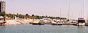
Bronte Creek is entered between two concrete break walls which extend 700 feet ENE into the lake from the north pier. There is a boulder break wall to the NE which extends which extends south and SE from shore with an elevation of 10 to 13 feet and protect a marina basin. Bronte Light (530) is located near the end of the north pier with an elevation of 30 feet, shown from a white circular tower of 25 feet in height and having a upper portion. Bronte Outer Light (529) is located at the south end of the east break wall at the entrance to the marina with an elevation of 27 feet and shown from a white circular tower with a red upper portion. There is a submerged power cable crossing from Bronte Light to Bronte Outer light. A submerged pipeline crosses the inner part of Bronte harbour. 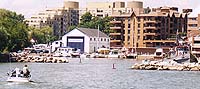
CAUTIONS Bronte Harbour is subject to silting. Depths of 6 feet were found in 1994. A highway bridge with crossing Bronte Creek at the inner end has a 20 foot clearance. CAUTION Wave Breaks there is a boulder wave break near the end of the inner end of the north pier extending 55 feet into the channel. There is a similar boulder wave break near the entrance to the inner harbour end of the south pier extending 55 feet into the channel. Both wave breaks have elevations of only 6 feet and may become awash in storms or high lake levels. CAUTION Current as there is a strong current in the harbour in the spring flood period . There may also be dangerous surf during storms. Bronte Harbour has launching ramps on the north shore and a double one east of the bridge. Bronte Harbour Yacht Club ( 3 ) is east of the bridge and is private with a reported 2 feet of water at the docks. Metro Marine is located on the NW shore and reported 3 to 5 feet of water at the docks. Metro Marine offers transient services, repairs, and dockage as per the below information. The downtown of Bronte is located near the harbour and provide a pleasant stop with banks, doctors, shopping, beer store and restaurants, however the nearest hospital is in Oakville. |
|
Metro Marine
|
Bronte Harbour Yacht Club
|
| Port Weller I Jordan Harbor I 50 Mile Point I Hamilton I I Burlington I Oakville I |